Building Movement & Structural Health Monitoring
Structural health monitoring, or SHM as we often call it, is all about keeping a close eye on the safety and stability of our infrastructure. Think bridges, tunnels, railways, and those towering city landmarks. These aren’t just big projects—they’re the backbone of our daily lives. When you’ve got the right monitoring in place, you spot issues early and keep things running smoothly. I’ve seen this make a real difference, especially when you’re dealing with unpredictable weather or busy construction sites.
So, how does it work in practice? It’s a clever mix of sensors, smart software, and a bit of know-how. For example, Leica Geosystems’ total stations and GNSS receivers can pick up the tiniest shifts—sometimes just a millimetre or two. That’s the sort of detail that can save a project from disaster. And when you add wireless sensors into the mix, like those from Move Solutions, you’re not just saving time on installation, you’re also cutting down on costs. I’ve found these wireless systems brilliant for tricky sites where running cables just isn’t practical.
But it’s not just about the kit. The real magic happens when all that data comes together in user-friendly platforms like Leica GeoMoS or the Move Cloud. You get live updates, clear visualisations, and instant alerts if something’s not quite right. Ever been woken up by a text saying a bridge has shifted? It’s not fun, but it’s better than finding out too late. These systems let engineers and site managers react fast, whether they’re in the office or out on site.
What’s really exciting is how flexible these solutions are. Maybe you’re just starting out and need a simple setup to monitor a new railway embankment. Or perhaps you’re managing a complex project, like a city centre high-rise or an old dam. You can scale up as you go, adding more sensors and features as needed. I’ve seen teams start with a single total station and end up with a full network of sensors—all feeding into one dashboard.
And let’s be honest, nothing beats peace of mind. When you know your structures are being watched 24/7, you can focus on the bigger picture. Whether it’s preventing landslides in Switzerland or keeping a busy London construction site on track, structural health monitoring gives you that extra bit of confidence.
If you’re looking to future-proof your projects, these monitoring solutions are well worth considering. They’re smart, reliable, and—best of all—they make your job that little bit easier.
Various equipment and techniques are used for structural monitoring, depending on the specific requirements of the projects.
Here are some common types of equipment and methods used in structural monitoring:
Vibration Sensors
Vibration sensors are used to measure the level of vibrations of oscillations in a structure. Excessive it used to be s indicator of structural instability or potential damage. Accelerometers and seismometers are commonly used vibration sensors.
Displacement Sensors
Displacement sensors, such as linear variable differential transformers (LVDTs) and displacement transducers, measure the movement or displacement of Structural components. They can detect shifts or settling in a building’s foundation or structural elements.
Tiltmeters
Tiltmeters are used to measure the inclination or tilt of a structure. They can help detect any changes in the building’s alignment, which might indicate settlement or structural movement.
Strain Monitoring Systems
These systems combine multiple strain gauges and sensors to provide comprehensive data on the structural health of a building. They are Often used in critical infrastructure projects, such as bridges and dams.
Geodetic Surveying Instruments
Geodetic instruments like total stations and electronic distance measurement (EDM) devices are used for precise measurements of positions and movements in construction projects. They can monitor changes in the position of structural points over time.
Wireless Sensor Networks
Modern structural monitoring systems often use wireless sensor networks to collect and transmit data to a central monitoring station. These networks can include various sensors for measuring different parameters and offer real-time monitoring capabilities.
Data Loggers and Data Acquisition Systems
Data loggers and data acquisition systems are used to collect, store, and analyse data from various sensors. They help in recording and processing the data generated by the monitoring equipment.
Remote Monitoring Software
Specialized software is used to process, visualize, and analyse the data collected from the monitoring equipment. It can provide alerts and warnings if the monitored parameters exceed predefined thresholds.
Structural monitoring in construction is essential for ensuring the safety and integrity of buildings and infrastructure. It allows engineers and project managers to detect early signs of structural issues, assess the impact of environmental conditions, and make informed decisions to prevent accidents or costly repairs. The choice of monitoring equipment and techniques depends on the specific goals and requirements of the construction project.
Different types of monitoring:
Manual Monitoring Using Retro-Reflective Targets
Manual (campaign) monitoring with retro-reflective targets remains a cornerstone of structural and geotechnical monitoring, offering a proven, cost-effective approach for projects where continuous, real-time data isn’t required. This method is especially valuable for infrastructure such as bridges, buildings, and retaining walls, where periodic but highly accurate measurements are essential.
The process starts with the installation of stable control prisms or retro-reflective targets—these are robust, weather-resistant markers fixed to key points on a structure. Surveyors use high-precision total stations, like the Leica TS16 or TM60, to record the initial positions of these targets. The Nova series, for example, features Auto-focus for fine positioning and ATRplus technology for reliable target recognition, even in challenging conditions.
At defined intervals—weekly, monthly, or after significant events—surveyors return to site and repeat the measurements, ensuring the instrument is set up in the same location for consistency. This repeatability is key: by measuring the same points in the same way over time, even millimetre-scale shifts can be detected and tracked.
Efficiencies in manual monitoring are now enhanced with Leica Captivate onboard apps, which automate setup, stakeout, and measurement routines. These tools reduce operator fatigue, minimise errors, and speed up data collection. Data is then transferred via HxGN GeoCloud Drive and processed in Leica Infinity, streamlining the reporting workflow.
Manual monitoring is ideal for projects with low to moderate risk, simple access, or where permanent sensor installation isn’t practical. It’s a trusted method that delivers reliable, repeatable results, and remains fundamental to many surveyors’ monitoring portfolios.

Semi-Automated Monitoring: Efficiency Meets Flexibility
Semi-automated (campaign) monitoring bridges the gap between manual and fully automated solutions, offering increased efficiency and data quality without the complexity or cost of continuous monitoring. This method is particularly well-suited to projects where regular, scheduled measurements are required but full automation isn’t justified.
The workflow begins much like manual monitoring, with the installation of stable control prisms outside the area of influence and monitoring prisms on the structure itself. The difference lies in the use of advanced tools such as the Leica TPS Monitoring App, which automates the process of searching for and measuring predefined point groups. This reduces time on site, eliminates missed or misidentified points, and ensures fast, error-free data acquisition.
Semi-automated systems can run measurement campaigns automatically over several hours, providing real-time feedback on data quality and alerting operators to any issues, such as instrument movement or outliers. Results are processed directly in the field, with automated quality checks to detect control point or station movement. Data is then uploaded directly to Leica GeoMoS Now! Survey Edition, a cloud-based platform that streamlines reporting and sharing, eliminating the need for manual data processing and reducing office workload.
This approach is particularly effective for projects with moderate risk profiles, where changes are expected to be gradual but regular, high-quality data is needed. It’s also a cost-effective way to increase monitoring frequency and reliability, and is especially valuable for sites with challenging access or where minimising site visits is a priority.
Full Automatic Monitoring: Continuous Insight with Advanced Technology
Full automatic monitoring represents the most advanced approach available, delivering continuous, high-precision data with minimal human intervention. This method is essential for high-risk, complex, or critical infrastructure projects where real-time insight and rapid response are paramount.
A typical automated monitoring system includes:
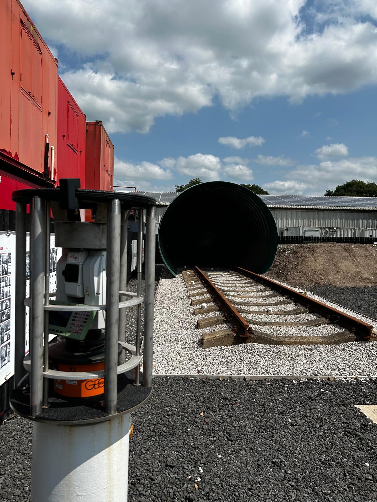
Leica TM60 or MS60 Total Stations: These instruments provide manual and automated aiming, with angle accuracy down to 0.5”, and can detect 3D deformations with millimetre precision. The MS60, in particular, offers automated scanning capabilities, capturing dense point clouds and monitoring surface deformations at up to 150 metres with prism-level accuracy. ATRplus technology and self-learning features ensure reliable operation in all weather and lighting conditions.
Senceive Wireless Sensors: Senceive’s triaxial tilt sensors, optical displacement sensors, and crack sensors are designed for durability, precision, and long battery life (up to 15 years). These sensors are waterproof (IP66/IP67/IP68 rated) and provide resolutions as fine as 0.0001° for tilt and 0.1 mm for displacement. They can be deployed across a range of environments, from railways and tunnels to bridges and earthworks, and communicate wirelessly via FlatMesh or GeoWAN networks for flexible, large-scale deployments.
Leica ComBox60: This plug-and-play communication and power unit connects up to three sensors, accepts any SIM card, and provides remote connectivity to GeoMoS software. With an IP66 rating and an internal battery, it’s built for harsh environments and ensures reliable data transmission.
Leica GeoMoS Now! Platform: GeoMoS Now! is a web-based platform that aggregates, analyses, and visualises monitoring data in real time, accessible from any device. It supports customisable dashboards, GIS integration, and secure data management, allowing users to configure alerts, generate automatic reports, and share data seamlessly across teams.
Integration with Other Sensors: Automated systems can also include GNSS receivers for absolute positioning, radar for large-area or remote monitoring, environmental sensors, and third-party geotechnical sensors, all managed through the GeoMoS suite and HxGN GeoMonitoring Hub for a holistic view of structural health.
Automated monitoring is especially valuable for high-frequency, high-risk scenarios—such as major construction projects, railway and tunnel monitoring, or sites exposed to geohazards. The system can be configured to provide instant alerts via email or SMS when thresholds are exceeded, enabling rapid intervention and reducing the risk of costly failures or safety incidents.

Why Choose These Monitoring Methods?
Manual Monitoring: Simple, cost-effective, and reliable—ideal for projects where periodic checks are sufficient and site access is straightforward.
Semi-Automated Monitoring: Increases efficiency and data quality, reducing time on site and minimising human error, perfect for regular campaign-based monitoring.
Full Automatic Monitoring: Delivers continuous, real-time insight with minimal intervention, essential for high-risk, complex, or inaccessible sites.
Each method can be tailored to your project’s risk profile, budget, and operational needs. Hexagon’s portfolio—including Leica Geosystems instruments, Senceive wireless sensors, and the GeoMoS Now! platform—ensures you have access to the most advanced, integrated, and flexible monitoring solutions available today.
If you’d like to discuss which monitoring approach best suits your project, or want to see a demonstration of these technologies in action, our team is ready to help you make the most informed decision for your asset’s safety and performance.
Frequently Asked Questions about Structural Health Monitoring
REQUEST A QUOTE