Castle Surveys Ltd leverages state-of-the-art drone technology to deliver fast, cost-effective and sustainable solutions for clients. From capturing 3D models to conducting the most precise drone inspections, our drone surveying service will help you streamline projects and adapt to a rapidly evolving industry.
The UAV (Unmanned Aerial Vehicle) inspections allow you to view and inspect even the most hazardous of locations. Previously inaccessible areas are now open with zero safety concerns as human inspectors are no longer required to venture into these dangerous zones. Whether it’s a precarious demolition site with falling debris or an underground piping system, the innovative technology from our drones will get the job done and provide you with crystal-clear imagery and high-resolution data.
What is a Drone Survey?
Using the latest UAV survey technology, we help clients streamline site assessments, monitor progress and aid decision-making using precise geospatial insights.
Understanding UAV Surveying Technology
High-resolution drone mapping uses unmanned aerial vehicles (UAVs) equipped with high-resolution cameras and LiDAR sensors to capture accurate aerial data. These drone surveys enable rapid and detailed topographic mapping, site inspections and volumetric analysis, with minimal site disruptions.
How Drone Surveys Compare to Traditional Methods
Compared to conventional surveying techniques, UAV surveys offer faster data collection, reduced costs, and easier access to hazardous or challenging areas. With real-time data processing and high-resolution imaging, they offer an efficient and comprehensive solution for a wide range of industries and uses.

Experience Market Leading Drone Surveying Services
Drone mapping services have uses across a diversity of applications throughout various industries. Your company can call upon our revolutionary drone technology for the following services:
Topographic Mapping
Advanced sensors and cameras help drones capture the three-dimensional features of a surface in two dimensions. This makes it ideal for topographic mapping to help with planning and development across many engineering projects. Topography also has uses in environmental studies, and our drones can help you map geological formations to view changes in the natural landscape.
Roof Inspections
Remote aerial inspections make it easier than ever to analyse and check roofing. There’s no need to risk accidents with humans using ladders or scaffolding to climb onto a roof and assess its structural integrity. High-quality drone videos and images allow for better insights coupled with thermal imaging and various sensors. Roof inspections are now faster, more effective and far safer.
Bridge Assessments
Use professional drone surveying services to conduct thorough bridge assessments. Ideal during the construction process or to carry out routine inspections throughout a bridge’s lifetime. The latest drone technology allows you to get closer to the bridge than ever before and view parts that were previously inaccessible to humans. LiDAR sensors and photogrammetry let the drones construct 3D bridge models with accurate measurements. This data can be used to run tests and predict things like maximum load bearing, etc. There’s no need to plan a complex and potentially dangerous bridge inspection with humans – nor will it be necessary to disrupt motorists by closing bridges to run full-scale inspections.
Environmental Monitoring
Environmental consultants will experience the benefits of drone mapping and UAV inspections for environmental monitoring. RTK Drones armed with state-of-the-art technology and sensors will create the perfect image of landscapes to monitor any changes caused by things such as global warming, new construction developments in the area, and so on. Drones with thermal imagery are particularly helpful in this domain as they can spot changes in atmospheric and surface temperatures, potentially identifying issues related to traffic in urban areas, etc.
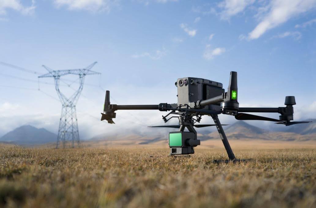
Power Line Surveys
Traditional power line surveys are arduous and incredibly hazardous. These surveys often require human workers to walk near live power lines and conduct assessments. Drone surveying prevents this from happening. Drones will be used to fly near power lines and track their pathing, utilising LiDAR and other sensors to create the perfect power line map. It’s ideal in the construction process to pinpoint where all the necessary power lines are before any building happens.
Moreover, power line drone surveys mitigate any safety risks and allow you to view the most hard-to-reach areas while capturing the highest-resolution imagery. This makes power line maintenance easier by pinpointing structural defects or potential issues a lot sooner than before.
Site Surveys & Photography
Construction projects will find many uses for drone surveying, particularly when conducting site surveys. It’s now easier than ever to get a birds-eye view of a construction site with geospatial data collection delivering everything you need to know about the area. Map out the site boundaries, figure out different elevations on the surface and monitor the site’s progress throughout the project.
Drone photography is a fantastic way of showing investors that you’re delivering and making progress. Use aerial images and videos to document your progress and create 3D images from the drone scans to demonstrate the next construction stage and what everything will look like when it’s finished.
Many More Services
Castle Surveys Ltd offers many more drone services depending on your needs and requirements. If you want to improve data collection and achieve better aerial inspections with zero risks, then enquire today, and we’ll arrange a consultation!
Enjoy The Benefits Of Drone Surveys & Inspections
Why opt for drone surveying over traditional methods? Calling upon drone technology offers a diversity of unmatched benefits, including:
Enhanced Efficiency
Drones allow for optimal efficiency as the process is as simple as setting up a drone and sending it into the sky. Moreover, you can use drones for autonomous inspections by mapping a pre-determined flight path and letting it fly. This reduces the overall survey/inspection time and means you have access to results a lot sooner than usual.
Heightened Safety
Utilising drone technology ensures that nobody is put in risky situations. Drones can be piloted from safe locations, meaning there’s no danger of someone venturing into hazardous areas.
Improved Precision
The enhanced safety benefits of drone surveys also mean you will enjoy more precision. A drone can fly into inaccessible areas for humans, allowing it to capture more images and data than ever before. There’s no need to worry about parts of a building falling during the inspection or navigating into hard-to-reach places. The drone will do it all, so you’re getting a fuller picture.
Real-Time Data Insights
Outdated survey methods often collect data, which then needs to be collated and turned into a report. Drone survey technology gives real-time data insights that let you see what’s happening and make sense of everything as it happens. This further streamlines the survey/inspection processes and stops you from waiting a few days/weeks to see the results of a survey. LiDAR drones use sensors to immediately convey all the data/information, which you can view on a screen with the drone pilot.
Better Decision Making
Speaking of LiDAR, it ensures accurate data collection along with other capabilities like photogrammetry and thermal imaging. You receive more data than you ever thought possible, which fuels the decision-making process across all stages of a project. Having access to more high-quality data encourages more informed decisions that yield positive results.
Reduce Project Costs
Combine all the benefits of drone surveys, and you will drastically reduce project operating costs. Drone surveys are more cost-efficient as fewer personnel are required – not to mention less equipment. Improvements in decision-making also contribute to this, helping you avoid wasting money on bad decisions. It all comes back to the convenience of drone technology, coupled with its ability to provide as much data as possible.
Better For The Environment
Drone surveys have a lower carbon footprint than many other survey methods and are far less intrusive. They’re a more eco-friendly option for companies seeking to be more sustainable and do less environmental damage.

Castle Surveys’ Drone Surveying Process
By combining expert consultation, cutting-edge drone technology and detailed data analysis, we provide high-accuracy results across a range of industries.
Pre-Survey Consultation
We begin every project with a thorough consultation to understand your objectives, site conditions and data requirements. Working closely with you, we will determine the most suitable approach for your UAV survey, planning ahead for an efficient project that delivers the necessary insights.
Data Capture Using Advanced UAV Technology
Our UAVs are equipped with high-resolution cameras and LiDAR sensors, as well as GPS technology, to capture precise aerial data. They can quickly and safely scan large areas to generate accurate orthophotos, elevation maps and 3D models.
Post-Survey Analysis and Reporting
Our expert surveyors process and analyse your remote sensing survey data using advanced CAD and GIS software. We then create final reports, featuring 3D models, detailed maps and actionable insights to aid your project.
Why Choose Castle Surveys Ltd For Drone Surveying Services
Castle Surveys Ltd uses the latest drone technology to deliver industry-leading solutions for clients across many industries. Our drone surveying services are fast, cost-effective and wholly sustainable. From capturing 3D models, conducting precise drone inspections or streamlining workflows, our services will help with the following:
- Minimise delays
- Reduce project costs
- Improve project safety
- Boost collaboration between departments
Not only that, but our drones capture as much data as possible, giving you extremely accurate geospatial survey data and high-definition imagery. These UAV data sets can then be seamlessly integrated into all of your existing workflows at any stage of the project lifecycle. This makes it easier for clients to use our data without needing to download or switch to new software applications.
We cater to a broad range of clients, including construction project managers, engineers, architects, infrastructure and utility companies, property developers, local authorities and environmental consultants. This shows our capabilities across a huge spectrum of industries and demonstrates just how diverse our drone surveys and inspections will be.
Castle Surveys Ltd is one of the fastest growing multi-disciplinary surveying practices in the UK, and we have years of experience providing drone surveying services. By integrating innovative technology with expert services, we’ve positioned ourselves as a trusted leader in this domain. We will give you all the tools you need to rise above the competition in an ever-changing world.
Book Your Drone Survey Today!
Whether you need a simple construction site drone survey or an intensive geological drone inspection, we’ve got you covered. Click here to contact us today and fill in our online booking form. We’ll take your details and get in touch with you to set up your drone survey and ensure it ticks all the right boxes to deliver the results you’re looking for.