Gross Internal Area
Net Internal Area
ITZA (Zoning)
Volumetric Surveys
When a construction project is undertaken, there is only a small window of tolerance regarding the difference in measurements on the plans, and the measurements of the real-life structure that is allowed. Indeed, this window of contractual tolerance is usually written into the contract of the project.
The issue is that if a project is outside of this window of tolerance then it will fail quality control and not be compliant with safety regulations. What this means is that it has to be reworked to meet these demands, which can be incredibly costly and time-consuming for all involved.
The good news is that there is a way to get the measurements of a project with accuracy, so you can easily show that it meets the approved design and specification. The solution is to get a construction verification survey completed. A topic you can find out more about below.

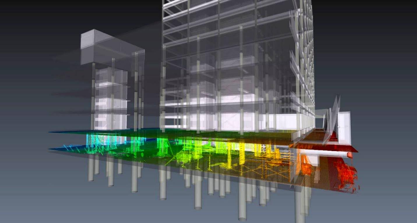
Construction verification surveys are assessments that use the most up-to-date state-of-the-art equipment to collect site measurements in the fastest and most efficient way. These measurements can then be compared to the as-built drawing, or architectural model of the building to check that the building is within contractual tolerance and that the rest of the project can proceed.
Accuracy is crucial to every construction verification survey, and that is why we only use the most state-of-the-art technology including 3D Laser Scanning and LiDar for measurement and feedback.
It is this technology which includes digital walkthroughs and 360-degree imaging that offers real-time visual updates and progress tracking, ensuring maximum accuracy at all times. Indeed, the 360 created by 3D laser scanning can be seen and turned to all angels. This provides users with an easy-to-understand and easy-to-use digital twin of the subject for comparison.
Additionally, these tools allow remote monitoring and improve collaboration among stakeholders. This means that even if stakeholders are not present on-site they can get a clear picture of whether the project meets contractual tolerance demands, and if not what might be done to rectify this. In this way, multiple stakeholders can collaborate from all corners of the globe, without ever having to be physically present on-site.
One of the most popular surveys that our expert team offers is the as-built survey. This is an extensive survey designed to verify dimensions and alignments in your project so you can compare them to the contractual tolerances. Our as-built surveys also measure the positions of structural elements in your project so you will have access to all the data you need for an accurate comparison.
We also offer 3d laser scanning and point cloud comparisons for construction verification use. The critical benefit of this is that these highly advanced methods offer incredibly precise verification down to infinitesimal numbers, ensuring fast and accurate measurements for your use.

GROSS EXTERNAL AREA
Gross External Area in broad terms means the whole are of the building taking each floor into account. This will include:
GEA will exclude:
Note that:
GEA is used for Town Planning, rating of residential property, council tax and building cost estimation including insurance.
In a bid to create greater consistency and confidence in the global property market, the IPMS (International Property Measurement Standards) Coalition was formed in 2013 and in 2014 IPMS for Office Buildings was published. Following the release of IPMS: Offices, the RICS have redrafted the Code of Measuring Practice (CoMP-6) and have re-published this as the Professional Statement for Property Measurement. This document is mandatory for all RICS members from 1 January 2016.
IPMS
There are three levels of IPMS which stands for International Property Measurement Standards: Office Buildings.
IPMS1
Used for measuring the area of a building including the external walls. This will calculate the sum of areas of each floor of a building, measured to the outer perimeter of eternal construction features and reported on a floor by floor basis.
IPMS2
Used for measuring the internal area and categorising the use of space in an office building. It can be used by asset managers, facility managers, valuers and cost consultants to provide data on the effective use of space by the tenant.
IPMS3
Used for measuring the occupation of floor areas in exclusive use, but excluding standard facilities and shared circulation areas. This is calculated on an occupier by occupier or floor by floor basis for each building.
Further Information can be found here on the RICS website.
GROSS INTERNAL AREA
Broadly speaking it’s the whole enclosed area of a building within the external walls taking each floor into account and excluding the thickness of the external walls. GIA is used for building cost estimation, estate agency and valuation, rating industrial buildings, warehouses, retail warehouses, department stores and many specialised buildings, property management for service charges, new homes valuation and marketing new residential developments.
GIA will include:
GIA will exclude:
Note that the areas excluded from GIA should be calculated and shown separately.
NET INTERNAL AREA
Broadly speaking, the usable area within a building measured to the face of the internal finish of perimeter or party walls, ignoring skirting boards and taking each floor into account. NIA is used for estate agency and valuation, rating of shops, shop rents, supermarkets, offices, etc, property management service charge.
NIA will include:
NIA will exclude:
ITZA (ZONING)
Zoning is a standard method of measuring retail premises to calculate and compare their value. It is used by both public and private sector surveyors and has been a method that has been applied in the UK to the analysis of shop rents and properties for rating purposes since the 1950s.
Shop or retail premises are divided into a number of zones each of a depth of 6.1 metres – or 20 feet.
Zone A closest to the window is most valuable, with the value decreasing with distance from the frontage: Zone B is the next 6.1 metres, then Zone C, until the entire depth of the retail area is allocated to a zone – anything after Zone C is usually defined as the remainder.
Castle Surveys are able to undertake stockpile surveys and volumetric calculations for either regular updates, asset management and auditing or one-off site visits to quarries, stock yards and construction sites. Using the latest Leica GPS equipment and drones (UAV, SUA), we can safely and accurately carry out these types of surveys and provide the data required.
This type of survey is undertaken to determine if the poured floor slab is level and within tolerance. For example, Castle Surveys was asked to undertake a level survey to establish where imperfections were in the existing floor slab in a large warehouse. Utilising our FARO 3D Laser scanner and LSS Survey Software we accurately surveyed the area and produced a Digital Terrain Model to show the client where the uneven areas were so they could be levelled in order to erect the racking in the warehouse. This was essential as the racking may have caused a health and safety issue for the company if it had collapsed due to the inconsistent floor level of the slab.
Using the very latest in total station technology our regularly updated fleet of structural monitoring instruments allows operatives to employ a diverse range of techniques to monitor movement across the broad spectrum of construction and engineering.
For when large numbers of measurements need to be taken within a short period of time it is often possible (and more practical) to install an automated total station structural monitoring system.
Monitoring surveys are a precise method of surveying in which structures or features which are thought to be moving or have the possibility of moving are repeatedly checked to determine the amount of movement or deflection. The amount of movement, if any, can be quantified and reported.
The movement can be due to adjacent site ground works, such as excavations or drilling works, or due to natural ground movement and settlement over a long period of time. Monitoring of deflection or deformation of structures due to load is another common application of this surveying technique, where the movement of a structure under load is observed, such as a bridge or supporting beam for example.
Our comprehensive range of survey services has recently expanded to include concrete and reinforcement bar scanning solutions.
Suitable across a broad range of projects and sectors, the latest ground penetrating radar (GPR) technology can locate and measure the layout of structural reinforcement within elements of the building structure including floor slabs, concrete beams and walls. It is also capable of detecting areas of voids within more unusual types of structure including sea wall defences and promenades.
By no means an exhaustive list, GPR concrete scanning can help identify the following…
Need a construction verification survey? Then choose the best with Castle Surveys Ltd.
Our dedicated team of experts use only the most cutting-edge and accurate tools like LiDAR and 3D laser scanning to collect data for your construction verification survey. This means you can save money by detecting errors early, reducing any rework. Our precise and in-depth surveys also help you to mitigate risk, while ensuring compliance and quality on your project.
We also have a proven track record of delivering accurate, reliable, and compliant construction verification survey results, delighting our clients with our speed and service.
Here at Castle Surveys Ltd, we understand that speed is of the utmost importance when it comes to construction verification surveys. After all, return site visits just mean more downtime for your team and more delays, which in turn can increase costs. The good news is that with state-of-the-art technology like 3D Laser Scanning, we can rapidly collect up to a million points of data per second. This means you’ll never have to worry about omissions of objects or features which means we’d need a second site visit.
Additionally, by choosing Castle Surveys Ltd you will get the extra benefit of all the digital documentation services including real-time site updates with 360-degree imaging and digital walkthroughs you need to enhance transparency and collaboration on your project.