Unravelling Data Collection Methods in Measured Building Surveys
July 16, 2024 2:00 pmConstruction and architecture are both fascinating fields. They’re both fields that call for a great deal of precision, too. In both construction and architecture, measured building surveys function as the “heart” of strong decision-making processes. These kinds of surveys are in many situations the most critical components of renovation or construction works. They provide helpful information that pertains to existing structures, and that’s how they educate builders, engineers and architects alike. Measured building surveys revolve around nuanced data gathering methods that strive to retrieve reliable data regarding building conditions, features and even dimensions.
Conventional Techniques in Surveying
Conventional surveying techniques in history are held in high esteem. They involve trusty devices that have accomplished a lot for the surveyors who were at the helm of measured building surveys. They currently retain their essential roles as well, especially in the retrieval of accurate building exterior measurements and beyond.
Photogrammetry
Photogrammetry has emerged as an economical and strong tool that achieves so much for measured building surveys. Advanced software assesses images that were shot from multiple angles. That’s how it designs three-layered building models with the highest degree of accuracy. Photogrammetry is able to retrieve geometrics and nuances that provide key data that relates to spatial design and so much more.
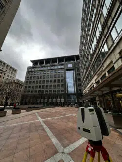
Laser Scanning
Laser scanning technology may well transform the building survey realm of tomorrow. It’s an advanced technique that relies on laser beams as a means of accurately and rapidly acquiring significant data points. That’s how it creates itemised building 3D portrayals. Laser scanning technology has the power to accelerate the journey of information sorting. Beyond that, it restricts errors that human beings can make, too. Thanks to its abilities, it’s a preferred option for elaborate structures and sizable projects.
Terrestrial LiDAR and Superior Detail
Terrestrial LiDAR or “Light Detection and Ranging” is a major thing for projects that need substantial precision and detail. It depends on laser pulses in order to set up nuanced building point clouds. The pulses this technology uses come from ground-based scanners. Terrestrial LiDAR can get inside thick vegetation in order to retrieve delicate surface features. Because of that, it is invaluable for everything from structural analysis to heritage preservation.
UAV Surveys and Saying Goodbye to Restrictions
UAVs or “Unmanned Aerial Vehicles” give aerial structure views and retrieve data from thrilling vantage focal points that just are not accessible to conventional methods. UAV surveys thrive in safety, scalability and safety and as a result are optimal for the assessment of progress in construction. They’re optimal for building facade evaluations and in the performance of surveys that involve surroundings testing, too.
Contact us at Castle Surveys For Your Measured Building Survey
Are you waiting for first-class assistance with measured building surveys and any and all related subjects? Contact the knowledgeable, experienced and hard-working professionals here at Castle Surveys Ltd as soon as you get the chance. Call 01530 569338 for a speedy quote.
This post was written by Paul Jackson
Comments are closed here.