Exploring Topographic Survey Methods: How Modern Site Data Is Captured
June 16, 2026 10:00 amArchitects use topographic survey data as the baseline for site layout and building design. Civil and structural engineers rely on it for drainage modelling, earthworks calculations, and foundation design. Planning consultants need it to support applications and flood risk assessments. Developers use it to de-risk site acquisition decisions. Contractors use it to verify existing conditions before construction begins.
In short: anyone who needs to understand a site accurately before making decisions about it. The method used to produce the data needs to match that purpose, and that’s where the detail matters.
What Is the Importance of a Topographic Land Survey?
Topographic surveys provide a precise, scaled record of the physical characteristics of a site: levels, contours, boundaries, and both natural and man-made features. That data underpins feasibility assessments, planning applications, drainage strategy, foundation design, and construction setting out.
Without accurate topographic data, designers are working from assumptions. And in construction, assumptions that prove wrong on site tend to be expensive to resolve.

Who Uses Topographic Land Surveys?
Architects use topographic survey data as the baseline for site layout and building design. Civil and structural engineers rely on it for drainage modelling, earthworks calculations, and foundation design. Planning consultants need it to support applications and flood risk assessments. Developers use it to de-risk site acquisition decisions. Contractors use it to verify existing conditions before construction begins.
In short: anyone who needs to understand a site accurately before making decisions about it. The method used to produce the data needs to match that purpose, and that’s where the detail matters.
The Core Topographic Survey Methods Used in the UK
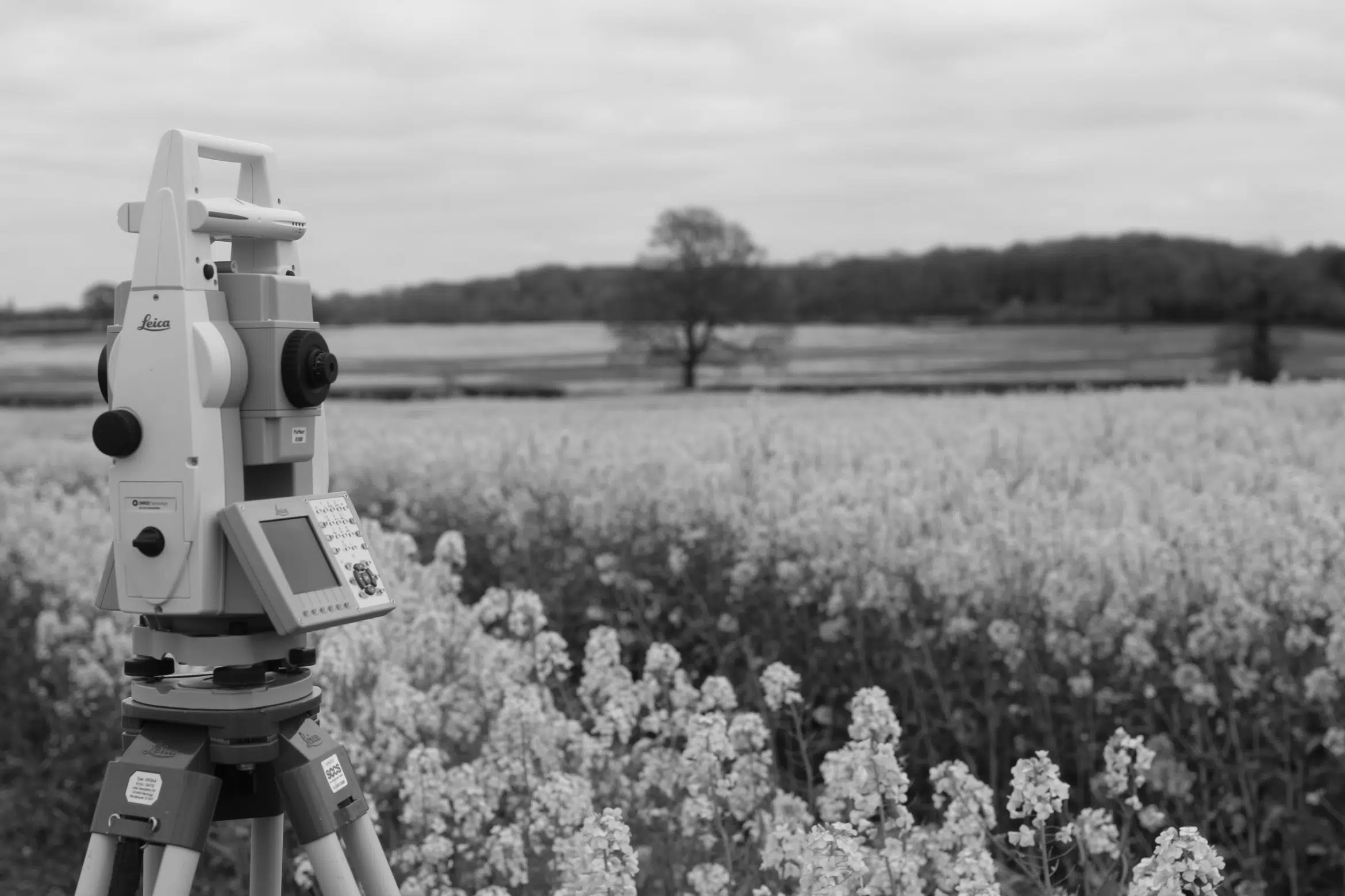
Total Station Surveys
The total station is the workhorse of precise, ground-based survey. It measures angles and distances to discrete points across the site, building up a detailed picture of ground levels and features from a fixed instrument position. The surveyor sets up at a known control point and takes readings to a prism pole held at each feature of interest.
The total station is the work horse of accurate, ground based survey. It uses angles and distances to discrete points across the site to build up a detailed picture of ground levels and features from a fixed instrument position. The surveyor sets up on a known control point and takes readings to a prism pole held on each of the features of interest.
The trade-off is pace. Each point requires a discrete measurement, which means total station work is methodical and time-intensive on large, open sites. For complex or restricted sites, though, it remains the most reliable method available.
GNSS and RTK Surveys
GNSS (Global Navigation Satellite System) survey, and specifically Real Time Kinematic (RTK) positioning, uses signals from multiple satellite constellations, including GPS, GLONASS, Galileo, and BeiDou, combined with a real-time correction feed, to establish centimetre-level positions on the ground. The surveyor carries a rover receiver across the site, collecting coordinate data continuously as they walk.
For open ground, RTK is fast, efficient, and highly productive. A surveyor with an RTK rover can cover large areas in a fraction of the time a total station would require. When connected to a network correction service such as OS Net, the data is directly tied to the OSGB36/BNG national coordinate system and the AOD height datum, making it immediately compatible with mapping, planning, and design workflows.
The limitation is sky view. Under dense tree canopy, close to tall buildings, or in deep urban canyons, satellite signal can be blocked or reflected (a phenomenon called multipath), which degrades accuracy. On these sites, GNSS alone isn’t sufficient. For more detail on how GNSS integrates into modern survey workflows, see our dedicated guide to GNSS in topographic surveying.
3D Laser Scanning
Where geometric complexity demands exceptional data density, 3D laser scanning is the method of choice. A terrestrial laser scanner emits rapid pulses of laser light and measures the return time of each pulse to calculate the distance to millions of individual points per second. The result is a point cloud: a three-dimensional dataset that captures every visible surface within range with millimetre-level precision.
For topographic surveys, laser scanning is used where the density of ground data matters: around existing structures, in areas with complex surface geometry, on heritage sites where non-contact measurement is required, and wherever the downstream deliverable is a BIM model rather than a simple 2D drawing. Point cloud data from a laser scan feeds directly into CAD, Revit, and BIM-ready survey deliverables.
The method requires careful setup and registration of multiple scan positions, which makes it more time-intensive per unit area than GNSS. It’s a targeted tool, applied where its density advantage justifies the cost.
UAV and Drone Surveys
Drone surveys have changed the economics of large-scale topographic data capture. An unmanned aerial vehicle (UAV) equipped with appropriate sensors can cover tens of hectares in a single flight, collecting either photogrammetric imagery or LiDAR data depending on the payload.
The image-based approach is called photogrammetry. It involves the use of overlapping aerial photographs that are processed by dedicated software to produce a 3D point cloud, orthomosaic imagery, and digital surface model. It is very effective on open well-lit terrain, and it produces visually rich outputs, as well as spatial data. The limiting factor is penetration, with photogrammetry recording the visible surface, and dense vegetation potentially hiding the ground underneath it.
LiDAR (Light Detection and Ranging) on a UAV addresses this. Airborne LiDAR pulses can penetrate vegetation gaps to reach the ground beneath, making it far more effective in wooded or scrubby terrain where photogrammetry would only capture the canopy. It’s the preferred method for ground-level data capture where vegetation is a significant factor.
All drone operations in the UK are subject to Civil Aviation Authority (CAA) regulations, and commercial surveys require appropriate operational authorisation. A surveyor quoting for drone work should be operating within a compliant framework.
Mobile Mapping
Mobile mapping surveys mount multi-sensor systems, typically including LiDAR scanners, cameras, and GNSS receivers, onto vehicles or other moving platforms. As the vehicle moves along a road or corridor, the system continuously captures the surrounding environment at high density and pace.
Mobile mapping is particularly efficient for highway surveys, infrastructure corridor mapping, large estate roads, and any linear project where the coverage area is extensive and vehicle access is available. Data density is high, and the vehicle-paced productivity means that kilometres of corridor can be captured in a single day. The method requires post-processing to register and quality-check the dataset, and its effectiveness depends on adequate satellite positioning data throughout the traverse.
For the equipment behind each of these methods in detail, see our article on the equipment behind each survey method.
How to Choose the Right Topographic Survey Method
This is where things get genuinely practical. The right method isn’t the one a surveyor happens to own or is most comfortable using; it’s the one that fits the specific constraints and requirements of your site. Here’s how to think through the decision.
Site Size and Access
Total station work is usually well served for small, limited sites, a plot for one building or a tight urban development with RTK GNSS for any open areas with good sky view. UAV photogrammetry or LiDAR for bulk coverage are most effective on large open sites, quarries, farmland and large greenfield allocations, with ground-based methods providing the detail around structures and boundaries. The greatest efficiency advantage of mobile mapping lies in linear infrastructure corridors, such as roads, pipelines and rail alignments.
Required Accuracy and Tolerance
“Centimetre accuracy” is a phrase that appears in a lot of survey marketing, but it means different things in different contexts. RTK GNSS in good conditions can achieve 10-20 mm planimetrically and 20-30 mm vertically. Total station work can achieve better than 10 mm across both axes. Laser scanning at close range can achieve 2-5 mm on individual points.
If your project involves setting out to tight construction tolerances, foundation design for a multi-storey structure, or interface with existing infrastructure, the accuracy method matters and should be specified in the brief rather than left to the surveyor’s discretion.
Terrain, Vegetation and Sky Visibility
Flat, open terrain with good sky view suits RTK GNSS for speed. Wooded terrain with dense canopy suits airborne LiDAR, because photogrammetry can’t see through the canopy and GNSS accuracy degrades. Deep urban plots surrounded by tall buildings suit total stations. Coastal or sloped terrain with complex surface features suits laser scanning where the geometry needs to be captured at density.
If your site has a mix of these conditions, the answer is almost certainly a combination of methods rather than one approach applied across the board.
Programme, Budget and Deliverable Format
The method affects both the time required for fieldwork and the time required for data processing and drawing production. UAV surveys cover large areas quickly in the field but require significant post-processing. Total station surveys produce data that can go directly into CAD with minimal processing overhead. Laser scanning produces rich data but requires registration and, if BIM is the output, modelling time.
Discuss the required deliverable format with your surveyor before fieldwork begins. A CAD drawing with contours and spot levels has very different method implications from a point cloud dataset or a Revit model. Getting clarity on the output first allows the surveyor to select the most efficient method to produce it.

Why Most UK Topographic Surveys Use a Hybrid Approach
Here’s something that rarely makes it into marketing material but is worth knowing: the vast majority of professional topographic surveys in the UK are carried out using a combination of methods, not a single technique.
A representative workflow for a mixed-character development site might look like this. RTK GNSS is used first to establish primary control points across the site and to capture open ground rapidly. A total station picks up the detail in areas where satellite signal is compromised, around buildings, under tree canopy, close to boundary walls. If the site is large enough, UAV photogrammetry covers the open areas at volume. Laser scanning is deployed around the existing structures where geometric complexity demands point cloud density.
All of that data is then registered to a common datum, typically OSGB36/BNG with AOD levels, and processed into a single coherent deliverable. The client receives one drawing, but behind it sits two or three distinct capture methods, each applied where it performs best.
This is why a thorough site visit and scoping conversation matters before a survey quote is issued. A surveyor who’s proposing a single method for a complex site is either working with incomplete information about the site, or defaulting to what they have rather than what the project needs.
Choosing a Survey Partner That Matches the Method to the Project
The best topographic survey isn’t the most technically sophisticated one; it’s the one that captures the right data, to the right accuracy, within the programme and budget available, and produces a deliverable that the design team can actually use.
Castle Surveys operates from offices across England and Wales, and our team selects methods based on site conditions and project requirements rather than a single preferred approach. Whether your project needs a straightforward RTK GNSS topo, a hybrid multi-method workflow, or a fully integrated point cloud dataset feeding into BIM, we’ll recommend the right approach before work begins.
For a fast, no-obligation quote on your project, visit our professional topographic survey services page.
Castle Surveys provides professional topographic survey services across the UK, using RTK GNSS, total station, drone, laser scanning, and mobile mapping methods matched to each site.
Contact Us
Frequently Asked Questions
How accurate is a topographic survey?
Accuracy is method and site condition dependent. A professionally carried out topographic survey should have a planimetric accuracy of ±10-20 mm and a vertical accuracy of ±10-20 mm under good conditions according to TSA Client Guide standards. In GNSS-based surveys, vertical accuracy may be degraded further on sites with poor sky view. Where tight tolerances are required, the accuracy needed should be specified in the brief and agreed with the surveyor prior to commencement of fieldwork.
Is a drone survey as accurate as a ground survey?
For most topographic applications, a well-controlled UAV photogrammetric survey with appropriate ground control points can achieve accuracy comparable to RTK GNSS work on open terrain. Airborne LiDAR can achieve similar results. However, both methods depend on good ground control and clear conditions, and neither matches a total station for precision at close range or in complex built environments. Drone surveys are a highly effective method for large open sites; they’re not a universal replacement for ground-based survey on constrained or complex sites.
How long does a topographic survey take?
It varies considerably. A small residential plot might require a few hours on site and a day or two for drawing production. A large multi-hectare development site with complex features might require several days of fieldwork and a week or more for processing and output. Programme is also affected by the method used and the deliverable required. A realistic programme estimate should be provided by the surveyor at the point of quoting, based on the specific site and agreed scope of work.
What’s the difference between GPS and GNSS in a survey context?
GPS (Global Positioning System) is the American satellite constellation specifically. GNSS (Global Navigation Satellite System) is the generic name used for all satellite navigation systems, including GPS, Russian GLONASS, European Galileo and Chinese BeiDou. Modern survey receivers utilize all available constellations simultaneously, leading to better reliability and accuracy than GPS-only systems. When a surveyor talks about GNSS they are talking about multi-constellation positioning, which is the norm for professional surveying in the UK.
This post was written by Paul Jackson
Comments are closed here.