The Role of a Hydrographer in surveys in River and Reservoir Projects
September 18, 2025 2:20 pmEver wondered what’s going on beneath the water’s surface when you look at a river or reservoir? It’s not all fish and stones down there—there’s a whole world of valuable information waiting to be discovered. Hydrographic surveys open that world for river and reservoir projects, providing vital data that keeps engineering on track, the environment protected, and operations safe.
What Are Hydrographic Surveys?
Picture this: You’re walking along a riverbank and you see the water flowing, but you don’t have a clue about what the riverbed actually looks like underneath. That’s where hydrographic surveys come in. These surveys map out what’s below the water—tracking depth, shape, and even underwater features you’d never spot from dry land.
Unlike your typical topographic survey, which sorts out what’s happening on the ground, hydrographic surveys are all about what lies beneath. This insight is crucial when it comes to managing water, keeping reservoirs functional, or making sure a new bridge has a solid (and safe) footing.
Honestly, I’ve lost count of the number of projects saved by knowing the riverbed profile before work started. Imagine finding out the bottom is much deeper (or siltier) than you’d planned once the contractors are on site… that’s not a good day for anyone.
So why bother with all this detail? Quite simply, it’s about accuracy, whether that’s calculating a reservoir’s capacity, monitoring where silt is building up, or getting flood defences right the first time.
The Role of a Hydrographer
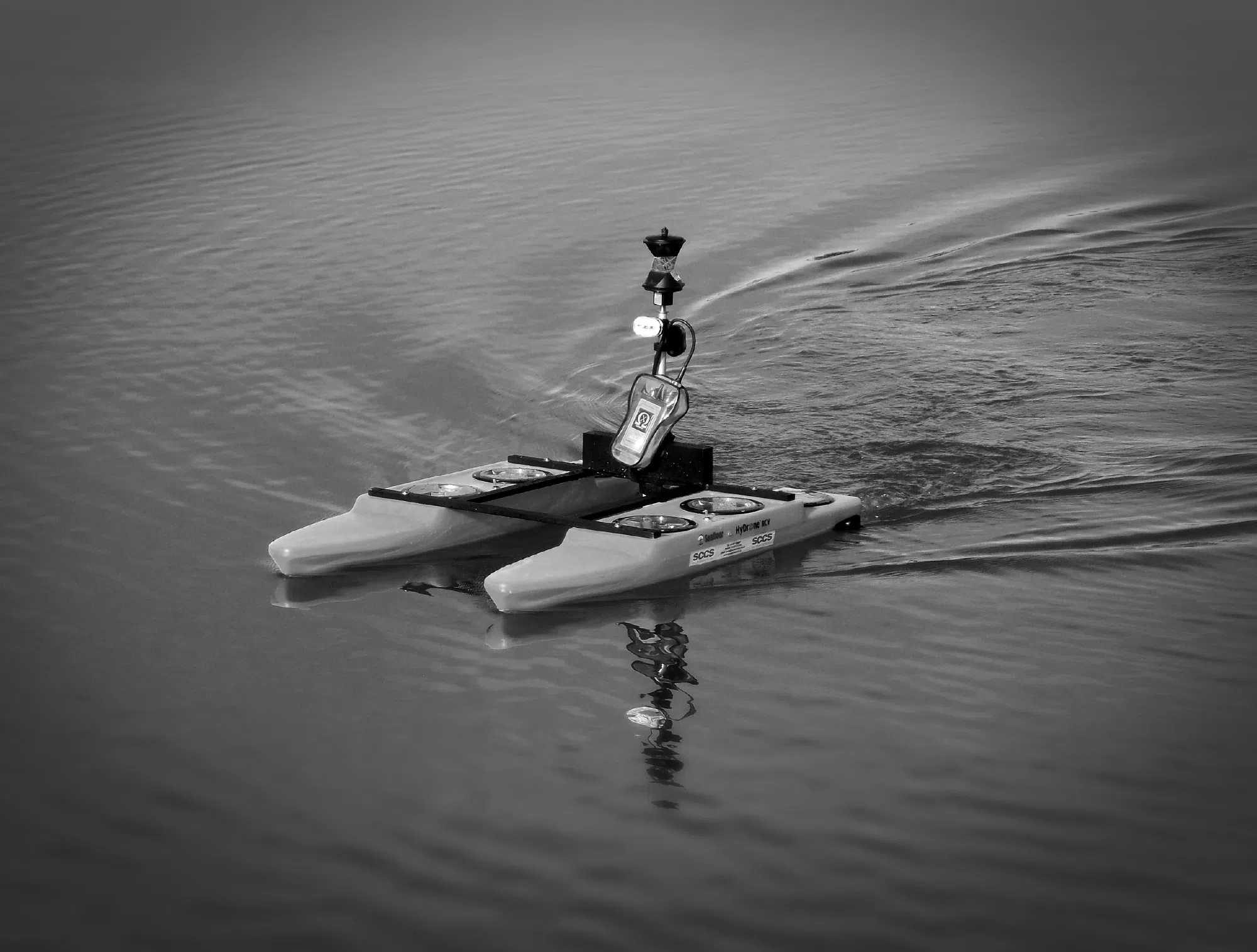
Now, who’s behind these surveys? Enter the hydrographer. I’ll admit, a hydrographer’s kit might make any tech-lover’s heart skip a beat. You’ll often find them at the water’s edge, toggling between sonar equipment, GNSS receivers, and echo sounders. Sometimes, you’ll spot them piloting an unmanned vessel right across the reservoir or down a quiet stretch of river.
But it’s not just about fancy tech. A hydrographer’s job is a blend of knowing what to look for, using the right tool for the job, and making sense of the data. Skills in mapping, operating specialised equipment, and interpreting what’s on the laptop screen into something engineers or ecologists can use? All in a day’s work.
I remember a job out on a sprawling reservoir where the echo sounder picked up a huge area of unexpected silt. It was a brilliant example of how much you can miss by guesswork. Thanks to the survey, we could give spot-on recommendations for maintenance, saving both time and cost for the client.

Survey Applications in River and Reservoir Environments
Flood Risk Management
Floods are unforgiving—but with the right data, they’re less of a mystery. Knowing the riverbed’s profile lets planners predict how water moves, where it’ll sit, and where banks might overflow. When rivers shift after a major storm, a fresh hydrographic survey is like getting a new map—essential for updating flood defence plans and pinning down those areas that need extra protection.
Silt and Sediment Monitoring
Imagine your reservoir or river slowly filling with silt and losing capacity with every storm. It’s easy to miss if you don’t keep an eye on things. Hydrographic surveys spot these build-ups, letting you time dredging and avoid surprises that can disrupt supply or safety. I’ve found it’s much easier to plan maintenance when you truly know which spots are building up, rather than relying on old anecdotes or “it’s always been fine” thinking.
Dam and Infrastructure Planning
Dams, bridges, or intake works all demand a precise understanding of what’s under the water. Underwater hazards, rocky outcrops, or sudden depth changes can scupper a design—or worse, threaten safety. So we get the facts first. Survey data provides a baseline to check if structures move or erode over time, meaning maintenance isn’t just guesswork.
Environmental and Habitat Assessments
Wildlife cares about rivers, too. From fish habitats to protected plant zones, knowing what’s under the water helps teams stay on the right side of regulations. Good hydrographic data supports ecological surveys, helps map out habitats, and gives planners the evidence they need for compliance. Ever found yourself needing to prove a protected area’s extent in front of regulators? Solid survey data is a game-changer.

Key Considerations for Inland Water Surveys
Planning a survey? Here’s what I’ve found can throw a spanner in the works if you’re not prepared:
- Access and Permissions: Not every stretch of water plays nice. You’ll often need the landowner’s green light—or official permission from authorities.
- Weather and Seasons: One week it’s calm, the next it’s suddenly ten times harder (and riskier) due to rain or a sudden cold snap. Every surveyor’s had that project where timing was everything.
- Data Integration: The best results often come from joining up the dots between hydrographic surveys and other methods—like traditional topographic or even drone surveys. That way, you get a full picture, from dry land down to the deepest trench.
- You can learn more about how we combine these approaches in [Topographic Surveys] and [Drone Surveys].
How Castle Surveys Makes Hydrographic Projects Work
At Castle Surveys, our hydrographers are more than just operators—they’re project partners. We use the latest sonar, GNSS, and unmanned platforms, but it’s the know-how and attention to the detail that sets us apart. We work closely with engineering and environmental teams to make sure the survey fits the real goals of your project.
From the first data point to the final model, we provide:
- Detailed digital terrain models you can drop straight into your designs.
- Contour maps and cross sections for planning or legal reports.
- Accurate calculations for volumes, sediment build-up, or change tracking.
- Friendly support and expert advice whenever you need it (I’ve found that a well-timed call or site chat can make the difference between a good project and a great one).
Ready to Dive In?
Hydrographic surveys are the foundation for safe, efficient river and reservoir projects. When the data’s right, everything else—engineering, compliance, even habitat protection—just falls into place.
Curious if you need a survey, or want yours delivered with top-tier accuracy, a bit of practical know-how, and genuine care for detail? Get in touch with Castle Surveys Ltd. Our team makes sense of the depths, so you don’t have to do it alone.
You might also find it helpful to explore how Topographic Surveys or Drone Surveys can tie into your next project, giving you all the information you need, land and water alike.
This post was written by Paul Jackson
Comments are closed here.