Overview Project Overview:
Castle Surveys Ltd was commissioned by the local council to undertake a comprehensive survey and deliver detailed digital solutions for the regeneration and renovation of Hull Arcade. This involved the preparation of a measured survey, an underground utility survey, and the creation of an extremely detailed LoD 400 Revit model. The team combined state-of-the-art laser scanning with drone surveys and inspection techniques in order to capture every nuance of this historic structure.
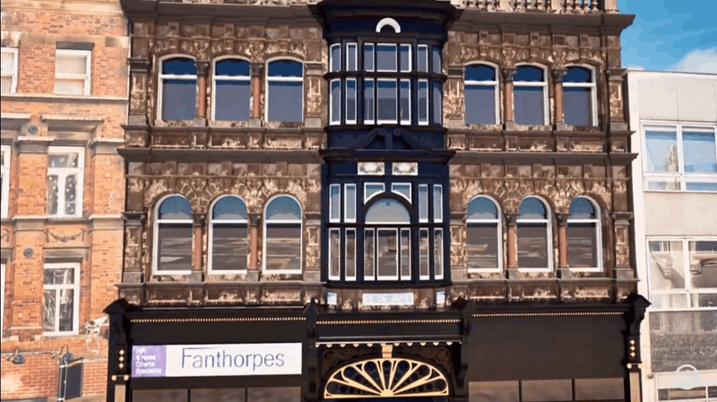
Historical Values of Hull Arcade:
Historical and architectural importance is immense in Hull. The Victorian arcade has remained one of the identifying features within the city’s commercial landscape with period-specific architectural details in decoration form through arches, iron works, and ornate facades. Unfortunately, it had suffered years of wear and tear, and the council wanted to give the arcade a new lease on life by preserving its historical value but bringing it into modern usage. This required very accurate and detailed surveying and mapping data, which was all to be captured by Castle Surveys.
Mapping and Surveying at Hull Arcade


ArcadeCastle Surveys utilized a multi-faceted approach in capturing all the details inside and outside. Our process involved laser scanning surveys, drone surveys, and underground utility mapping to garner comprehensive data from all aspects of the building and surroundings.
Measured Building Survey: Capturing Intricate Detail with Leica RTC360
We undertook a full-scale measured survey of the interior and exterior of the arcade using the Leica RTC360 laser scanner. This laser scanning survey technology allowed us to capture millions of precise data points per second, building up a 3D point cloud of every detail in the structure. In all, we placed the laser scanner in strategic positions over 1,200 times around the arcade, just to ensure no corner, whether hidden or unreachable, was left unscanned.
The laser scanning survey provided us with a wealth of accurate data crucial for the generation of the LoD 400 Revit model. This point cloud data served as the backbone for capturing this model in minute detail, right from ironwork to columns to arches. Hence, we are able to make a perfect digital twin of the arcade with high-density laser scanning, which is of paramount importance to the design and construction teams tasked with executing the renovation.
Drone Survey and Roof Inspection: DJI M300 with P1 Camera
In addition to our ground-based laser scanning survey, we also undertook a comprehensive drone-based survey of the arcade roof. The roof of Hull Arcade includes complicated architectural features such as chimneys and skylights, for which it was quite hard to capture with traditional means. To this end, we used the DJI M300 fitted with the P1 camera-a highly precise full-format frame camera specifically designed for high-resolution aerial imaging.
The drone survey allowed the entire roof to be inspected, taking hundreds of overlapping pictures which stitched together into a full detailed model of the roof. We could create a 3D point cloud of the roof area through photogrammetry. Using the P1 camera means a lot of the intricate details on the roof are captured highly accurately, complementing the data captured by the laser scanner.
Underground Utility Mapping and Survey
Another major activity of the project is locating and mapping all underground infrastructure. An underground utility survey was conducted using advanced ground-penetrating radar and electromagnetic locators. Such utility surveys provided the exact location and mapping of underground services, including water, gas, and electrical lines around the arcade. This was information critical to the renovation, as it ensured that no disruption of service would occur during construction and that the site would be a safe place to work.
Point Cloud: The Foundation of the LoD 400 Revit Model
The combined data from the laser scanning survey, drone survey, and underground utility survey formed one united point cloud that served as the basis for the LoD 400 Revit model. But what is a point cloud?
It is the digital representation of an object’s surface and environment that has been made by capturing millions of data points in 3D space. These points carry X, Y, and Z coordinates, defining the exact shape and dimension of the structure. The point cloud generated from the laser scanning survey and drone survey allowed us to create a very accurate digital twin of Hull Arcade, which in turn helped ensure accuracy that the LoD 400 model represented the actual site physical conditions.

Post-Processing: Creating 3D Models Using Leica CloudWorx
Once we had captured the point cloud data from our laser scanning survey and drone survey, we processed and refined it using the Leica CloudWorx. Leica CloudWorx is a plug-in that allows for the easy integration of point cloud data into the software platforms such as Revit, AutoCAD, and Navisworks. On this project, CloudWorx was of vital importance to ensure efficiency and accuracy in the process of creation within the Revit model.
Working with Large Point Clouds:
The point cloud from over 1,200 scan positions and hundreds of drone-captured images was immensely big. CloudWorx allowed us to efficiently handle such large datasets within Revit and ensured smooth post-processing without sacrificing accuracy.
Feature Extraction:
Among the main advantages of using Leica CloudWorx is the fact that it allows the retrieval of the most important architectural and structural features in one fell swoop. Aligning this with actual construction site conditions, the final LoD 400 model had been directly modeled from the point cloud for elements such as walls, beams, and columns in Revit.
Clash Detection and Analysis:
Integrate the point cloud data into Revit to perform clash detection through finding potential conflicts between the existing structure and proposed renovation designs. It avoids costly construction errors and thus can assure smooth project execution.
Precise Measurement:
The point cloud allowed us to take very accurate measurements in Revit and ensured that everything about the geometry was correctly captured and modeled. This was even more critical to maintain historical integrity in most areas of the arcade while renovation work was underway.

Conclusion: Complete Surveying and Modeling of Hull Arcade
The renovation of Hull Arcade requires an extremely detailed approach to the survey, map, and digital modeling. Because advanced laser scanning surveys, drone surveys, and underground utility mapping were used, Castle Surveys Ltd was in a position to capture a really detailed dataset that provided the basis for a detailed LoD 400 Revit model.
With the latest tools at hand, like the Leica RTC360 laser scanner, the DJI M300 drone with the P1 camera, and Leica CloudWorx, our work has been able to amply capture every detail of this historic structure so that renovation work could continue with full confidence. This point cloud from these surveys has enabled the modelling not only to be facilitated but also allowed the building features to preserve their historical features while integrating modern upgrades. The specific importance of the project is that it helps to deliver the high demands for successful restoration and renovation projects in historic buildings using highly accurate surveying, mapping, and inspection techniques.