Complex Land, Building, and Utility Surveys at Network Rail Office, Paddington Train Station
Client: Network Rail Project: Paddington Train Station Network Rail Office Services Provided: Topographic Land Survey, Measured Building Survey, PAS128 Underground Utility Survey, CCTV Drainage Survey and Revit Modelling Survey Equipment Used: Leica TS16 Total Station, Leica RTC360 Laser Scanner, Prosec GPR, Vivax Locators, Hydraulic Manhole Lifters
Background
Paddington Train Station is one of London’s most iconic railway stations, designed by Isambard Kingdom Brunel and opened in 1854. Being a pivotal point within the UK rail infrastructure, connecting millions of passengers to all corners of the country, renewal work is crucial. Infrastructure around the station, housing Network Rail offices, has grown old over the years. These offices were in dire need of a detailed survey that would assist in their modernisation and renovation process.
Castle Surveys Ltd was commissioned to undertake a comprehensive suite of surveys at the station, which were aimed at providing the data required to support the renovation process. This encompassed a range of survey activities including topographic land, measured building, PAS128 underground utility, CCTV drainage, and Revit modeling. Due to the fact that the station is always in use, we undertook the surveys at night shifts to minimize the level of disruption to passengers and services as much as possible.
Scope of Works
Castle Surveys Ltd was appointed to deliver a suite of surveying services, which would enable Network Rail to fully understand the condition of the office buildings over and the surrounding land.
Topographic Land Survey
Our land surveyors used a Leica TS16 Total Station, renowned for high-precision measurements to capture the topography of the site. With its advanced AutoHeight feature and 1″ angular accuracy, the TS16 enabled our team to map the surrounding area with assured accuracy, documenting site levels, boundaries, and other key land features. This was important information to ensure that renovation works could be planned in full awareness of the topographical conditions.
Measured Building Survey
The Laser Scanner used for the measured building survey is Leica RTC360. For its speed, the RTC 360 can capture up to 2 million points per second. We use this to capture all architectural and structural features in the Network Rail offices. It was then converted into a detailed 3D point cloud that could provide millimeter accuracy for the internal and external features of the building. The Measured Building Survey ensured the design team received all the accurate information that might be required for renovation plans.
PAS128 Underground Utility Survey
Our utility survey, therefore, used Prosec GPR and Vivax Locators to ensure compliance with the PAS128 standard. In carrying out this survey, we were in a position to map out and identify all existing utilities including, but not limited to, water, gas, and electrical lines. With the precise identification of these buried services, there was a minimal chance of disrupting any key utilities during construction. Results The main types of equipment used in the utility survey of the area, the Prosec GPR and Vivax locators, have been comprehensively carried out and highly reliable, meeting the industry standards.
CCTV Drainage Survey
A comprehensive CCTV drainage survey was done at the renovation planning stage. Deployment of hydraulic manhole lifters provided safe access to the drainage system, whereas CCTV cameras viewed the condition inside the pipes. This gave our surveyors the opportunity to establish exactly what current condition and status the drainage infrastructure was in. This detected blockages or other damage to further operations. The drainage survey provided them with essential information that would allow Network Rail to plan work around potential repairs needed.
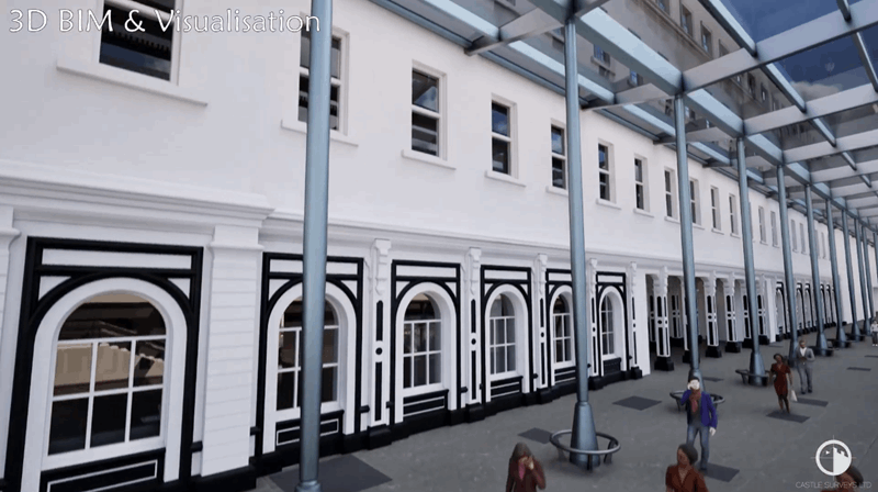
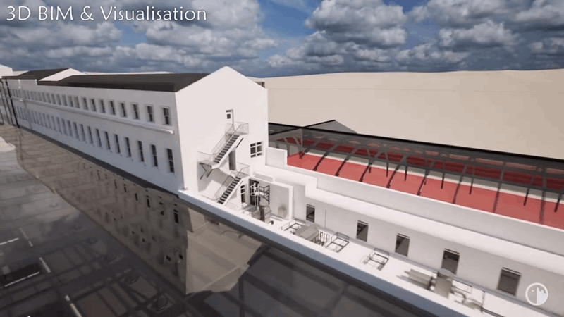
Revit Modelling
With the data collated from topographic land surveys, measured building surveys, and utility surveys, Castle Surveys created a 3D Revit model of the Network Rail offices. This BIM allowed design and construction teams to visualize the existing structure more clearly, plan the renovations more efficiently, and assess the impact of the alterations that would be suggested. The Revit model was used as a shared source for the renovation, hence ensuring that all aspects of the office building were accurately taken into consideration in the model.
Given that Paddington Station had remained in operation during the survey, all work was done at night and designed to minimize disruption for passengers and rail services. Accordingly, a team of 10 surveyors was mobilized to work in the very small time window available each night, laying on the necessary land surveys, building surveys, and utility surveys in an efficient manner. Operations on the night shift did not go out of kilter, despite challenges involved in working within a live rail environment; all the planned survey activities have been carried on schedule without incidents.
Challenges Overcome
Live Rail Station Operations
The surveys in the live rail environment were a careful affair to plan. Scheduling the work at night ensured our team created minimal disruption to station operations. We kept the public and our team safe while completing the required tasks by maintaining strict safety protocols.
Historical Infrastructure
Owing to the fact that Network Rail offices are part of the historic structure at Paddington Station, the building survey and utility survey had unique challenges. The age of the infrastructure demanded extra concern in detailing utilities and structural features existing at the site.
Coordination Across Multi-variate Survey Types
Several on-site surveys were performed at the same time. Some coordination was required. One grand team of land surveyors, building surveyors, and utility survey specialists. The effort put by our teams made the data gathering from GPR surveys, CCTV drainage surveys, and building surveys effective and accurate.
Results and Outcomes
Castle Surveys Ltd successfully undertook all elements of the work and provided Network Rail with a comprehensive package of survey data for the site. The topographic land survey, measured building survey, and utility surveys furnished Network Rail with accurate and reliable information for the renovation plans. The final Revit model supported a detailed 3D representation of the site for the design and planning phases.
Key deliverables include:
Very accurate and detailed topographical map for the surrounding ground to effectively plan the area. Very accurate measured building survey of Network Rail offices, which is crucial during the renovation process. Full compliance with PAS128 for the underground utility survey that locates and maps all existing utilities. A comprehensive CCTV drainage survey was executed to ensure the drainage infrastructure was fully assessed prior to construction. A detailed Revit model serving as the principal reference for renovation purposes.
Conclusion
This case at Paddington Train Station demonstrated that Castle Surveys Ltd is fully capable of delivering quality land, building, and utility surveys, even in the most difficult conditions. Using the very latest equipment, such as the Leica TS16, Leica RTC360, Prosec GPR, and Vivax locators, our team of professional surveyors was able to provide Network Rail with the accurate data they needed to move forward with their renovation plans. The successful delivery of the project, carried out at minimal disruption to one of London’s busiest stations, underlines our ability to manage complicated surveying tasks with efficiency and effectiveness.
In the Paddington Station project, land surveyors of Castle Surveys Ltd, utility survey specialists, and measured building survey teams were involved to work in perfect coordination, bringing out another example of our commitment to excellence in geomatic surveying and delivering precise, actionable data for complex infrastructure projects.