Precision in Utility Detection: Understanding PAS 128 QL-B
Utility detection is an important aspect of infrastructure projects. Accurate mapping of underground utilities is critical for avoiding costly disruptions, project delays and safety hazards during construction. At Castle Surveys, we specialise in PAS 128 QL-B surveys, a standardised method for subsurface utility engineering that delivers high-quality results while meeting PAS 128 compliance standards.
What is a PAS 128 QL-B?
Defining Quality Level B Surveys
PAS 128 QL-B refers to a specific level of survey conducted to locate and map underground utilities. It is part of a quality-level classification defined by the PAS 128 standard, which provides guidelines for utility detection methods. A Quality Level B (QL-B) survey uses noninvasive techniques to detect the presence and general location of utilities, but it does not offer full confirmation of utility depth or condition.
Utility detection in QL-B surveys is primarily conducted using Ground-Penetrating Radar (GPR) and Electromagnetic Location (EML) tools, which provide precise utility location data. While QL-B does not offer the same level of accuracy as more invasive Quality Levels like QL-C, it offers a reliable method for identifying potential utility locations without physically exposing them.
Importance of Compliance with PAS 128 Standards
Adhering to PAS 128 standards is key to ensuring that utility surveys are consistent, accurate and reliable. The PAS 128 assessment protocol is widely recognised in the industry for its rigorous guidelines on utility detection. Compliance with these standards is essential for ensuring that the survey data is valid and usable in subsequent stages of project planning, design and construction.
Failure to meet PAS 128 standards can lead to errors in utility location, which can cause project delays, unexpected costs and potential safety hazards. By following the PAS 128 guidelines, we guarantee that our clients receive reliable, high-quality data for their utility mapping needs.
Key Methods Used in PAS 128 QL-B Surveys
Ground Penetrating Radar (GPR)
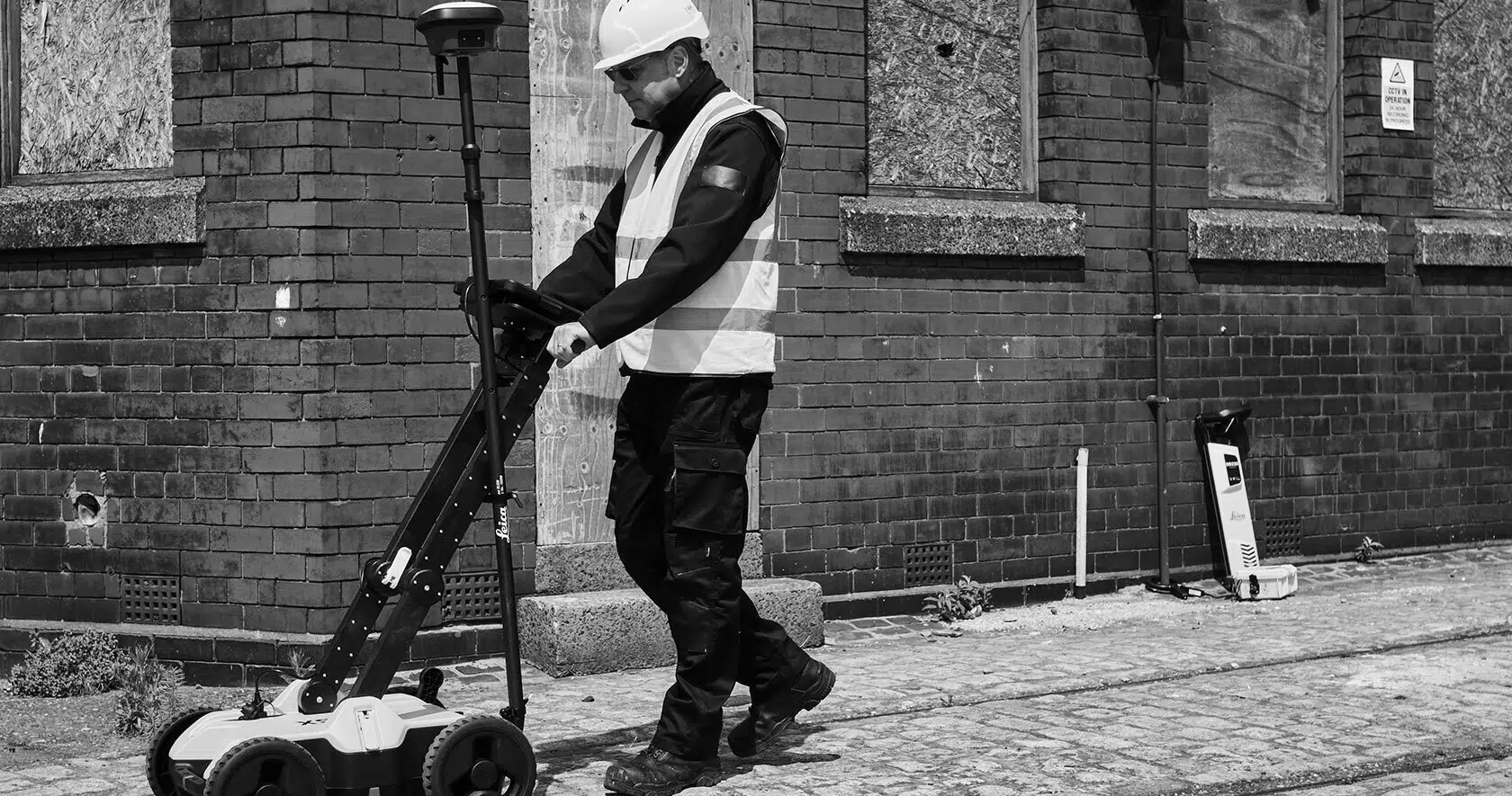
Ground Penetrating Radar (GPR) technology is one of the primary tools used for underground utility surveys. GPR is a non-invasive, reliable and highly effective method for detecting and mapping subsurface utilities and structures.
GPR sends high-frequency radar waves into the ground, which bounce back after hitting a solid object, such as a utility pipe or cable. These returning signals are then analysed to determine the precise location, depth and condition of the utility infrastructure.
The benefits of this technology are:
- It’s non-invasive: GPR surveys can be conducted without the need for excavation, reducing the risk of damage to the surrounding area.
- It’s highly accurate: GPR provides detailed, real-time data about the location and condition of utilities.
- It’s adaptable: GPR is effective on a wide range of materials, including concrete, metal and plastic, making it ideal for mapping various utility types.
Other advanced methods and tools, such as electromagnetic detection and utility tracing, are also used to enhance the accuracy of surveys further and ensure all utilities are identified.
Electromagnetic Location (EML)
Electromagnetic Location (EML) is another key method used in PAS 128 QL-B surveys, particularly for detecting metallic utilities such as copper or steel pipes. EML generates an electromagnetic field around a utility, which can then be traced using specialised equipment. This method is highly effective for accurately locating metallic utilities and provides detailed depth information, which is crucial for excavation planning.
EML is often used together with GPR to provide a more comprehensive utility map. While GPR is effective for non-metallic utilities, EML excels at locating metallic utilities, ensuring that both types are thoroughly mapped.
Data Integration and Analysis
After employing utility detection methods, the next step is integrating and analysing the data. At Castle Surveys, we use advanced software to process and compile the raw data collected during the survey. The result is a comprehensive utility map that clearly indicates the location, type, and depth of utilities.
This data is carefully analysed to ensure accuracy, and the final report is designed to be easily understandable for engineers, architects and construction teams. By compiling and analysing the data, we can provide actionable insights that streamline the project planning process and mitigate potential risks.
Benefits of PAS 128 QL-B Surveys for Projects
They Reduce Project Risks
PAS 128 QL-B surveys significantly reduce the risks associated with construction projects. Accurate utility detection prevents the risk of damaging underground utilities, which can result in expensive repairs, project delays and safety hazards. By conducting a QL-B survey early in the project, you can identify utility locations before excavation begins, ensuring that utilities are avoided or relocated if necessary.
Utility mapping also helps identify potential conflicts between existing utilities and planned construction, which allows project managers to make informed decisions and avoid costly mistakes during the construction phase.
They Enhance Safety Standards
Ensuring the safety of workers and the public during excavation is a primary concern for any construction project. PAS 128 QL-B surveys play an important role in improving safety standards by providing accurate utility maps that help avoid dangerous utility strikes. With detailed knowledge of utility locations, construction teams can take the necessary precautions to protect workers and the surrounding environment during excavation.
Early utility detection also helps prevent accidents caused by unexpected encounters with high-risk utilities, such as gas or electrical lines, enhancing overall safety on the job site.
They Support Efficient Project Planning
Accurate and comprehensive utility maps streamline the project planning process. By identifying and mapping existing utilities, you can avoid last-minute changes to the design, ensure that all utilities are accounted for and optimise the layout of infrastructure. This level of insight helps architects, engineers, and contractors plan more effectively and reduces the likelihood of unexpected complications during the project.
With clear data about utility locations, teams can allocate resources more efficiently, plan excavation work more accurately and avoid delays caused by unforeseen utility issues.
Castle Surveys’ Expertise in PAS 128 QL-B Surveys
Advanced Technology and Techniques
At Castle Surveys, we use the latest technology to ensure the highest level of precision in our PAS 128 QL-B surveys. Our team is equipped with advanced Ground-Penetrating Radar (GPR) systems and Electromagnetic Location (EML) tools, which allow us to detect both metallic and non-metallic utilities accurately. Our state-of-the-art equipment, combined with expert knowledge, guarantees reliable results for every project.
Commitment to Quality Assurance
We take pride in our quality assurance survey process, ensuring that every survey meets the highest standards of accuracy and reliability. Our team adheres to a strict methodology, conducting thorough checks and validation procedures to guarantee that all data is correct. We deliver clear, actionable utility maps that can be used with confidence in the planning and construction phases of your project.
Successful Case Studies
Castle Surveys has successfully completed numerous PAS 128 surveys for various projects, including large-scale infrastructure developments, urban construction, and environmental assessments. Our past clients have praised our thoroughness and attention to detail, and we are proud of our track record in delivering high-quality utility mapping services. These case studies demonstrate our ability to handle complex survey projects with precision and efficiency.
How to Book a PAS 128 QL-B Survey with Castle Surveys
Consultation and Planning
Booking a PAS 128 QL-B survey with Castle Surveys begins with a consultation to discuss your project requirements. During this stage, we will assess the site, review the scope of the survey, and identify any potential challenges. Based on this information, we will create a tailored survey plan that meets your needs.
Survey Execution and Reporting
Once the survey plan is in place, our team will carry out the utility detection survey using advanced technology and proven techniques. After the survey is completed, we will process the data and generate a comprehensive report detailing the location, type, and depth of utilities. This report will be easy to understand and provide actionable insights for your project.
Phone: 01530 569338
Email: info@castlesurveys.co.uk