Accuracy. Efficiency. Certainty. Those three things sit at the heart of every successful construction project, and they all begin with reliable digital models.
At Castle Surveys, we provide professional Scan to BIM services that transform physical environments into intelligent, data-rich 3D Revit models. Using advanced high-definition 3D laser scanning, we capture every architectural, structural, and MEP detail with millimetre precision before our in-house modelling specialists convert the data into fully functional Revit deliverables.
It’s not just about creating 3D geometry, it’s about creating clarity. Our end-to-end process acts as the bridge between on-site reality capture and full Building Information Modelling (BIM) surveys, ensuring design teams, contractors, and facility managers all work from one consistent, accurate source of truth.
Whether you’re planning a complex refurbishment, verifying as-built conditions, or coordinating multiple disciplines within a large project, Castle Surveys helps you remove guesswork, reduce risk, and deliver confidently with smart, reliable BIM data.

What Is Scan to BIM?
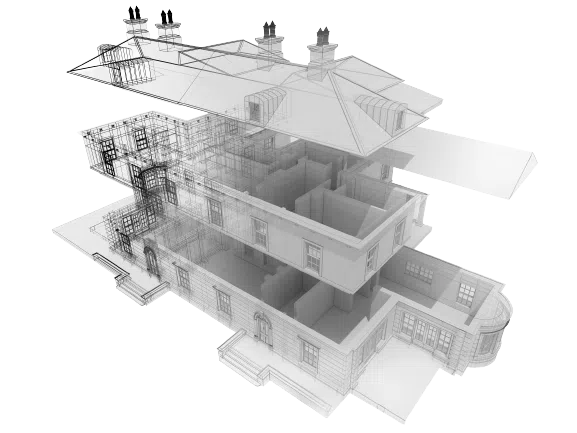
At its core, Scan to BIM is the process of digitally mapping the built environment and converting that data into an intelligent 3D model that behaves like the real building.
The workflow starts with high-precision laser scanning on-site, capturing millions (sometimes billions) of data points known as a point cloud. This point cloud accurately depicts every visible surface, from walls and beams to ductwork and roof structures.
That dataset is then translated into a fully developed Revit model where every element, such as walls, floors, columns, and MEP components, is defined as a real-world object. Unlike traditional CAD drawings, which only show geometry, a BIM model contains parametric data: materials, dimensions, relationships, and spatial behaviour.
Architects, engineers, and contractors can then use the model for design, coordination, clash detection, construction sequencing, facility management, and long-term asset maintenance.
In short, Scan to BIM transforms a physical structure into an intelligent digital twin, a living model you can design, analyse, and build from with complete confidence.
Our End-to-End Scan to BIM Workflow
One of the primary reasons clients choose Castle Surveys is that we manage the entire process seamlessly, from site capture right through to model delivery. There are no middlemen, no fragmented workflows, and no loss of data integrity.
Here’s how our Scan to BIM service works in practice:
Step 1: Reality Capture
Our survey teams visit your site with high-definition 3D laser scanning systems to record every visible element of the structure. In minutes, each scanner captures millions of measurement points from multiple stations.
This non-intrusive process is safe, fast, and highly accurate. Even complex or occupied sites can be captured efficiently with minimal disruption to operations. When required, we also use aerial drone surveys for rooflines, towers, or inaccessible elevations, ensuring complete data coverage from ground to ridge.
Step 2: Point Cloud Registration
Once the raw scans are collected, our technicians align (or “register”) them into a single cohesive dataset. We clean, filter, and georeference the point cloud to an appropriate coordinate system, often tied to Ordnance Survey data, for absolute positional accuracy.
This step produces a high-quality 3D representation of the building or site, ready for modelling.
Step 3: 3D Modelling
The registered point cloud is passed to our dedicated 3D Revit modelling team, who bring the data to life in Autodesk Revit. Here, we interpret every element – architectural, structural, and MEP – according to the agreed Level of Detail (LOD).
Our skilled technicians don’t simply trace lines; they construct parametric Revit families that behave intelligently within your BIM environment. Whether you need general layouts for early design or intricate MEP models for coordination, we deliver models that are clean, accurate, and optimised for performance.
Step 4: QA and Clash Detection
Before any model leaves our office, it undergoes a rigorous quality assurance check. Every component is compared against the original point cloud data to ensure positional accuracy within millimetres.
We also offer optional clash detection and validation services, helping project teams identify potential conflicts early, long before they reach the site. The result? Reduced rework, fewer delays, and full confidence that every dimension is correct.
This turnkey approach, from physical measurement to digital intelligence, means we supply not just drawings or geometry, but a trusted foundation for your project’s success.
Tailored Levels of Detail (LOD) for Your Project
Every project demands a different level of precision. Some require simplified architectural layouts; others need intricate engineering models detailing every bracket and beam. At Castle Surveys, we adapt our modelling to your exact specifications, producing Revit models aligned with recognised Levels of Detail (LOD) standards.
Here’s how we define them:
- LOD 200 – Conceptual Design Stage
Provides approximate physical shapes, sizes, and locations of major components.
Best suited for feasibility studies, space planning, and early-stage coordination. - LOD 300 – Design and Documentation Stage
Represents accurate geometry, defined materials, and precise placement. This is the most common requirement for architects, planning applications, and project design coordination. - LOD 400 – Fabrication and Construction Stage
Includes fabrication-level detail suitable for manufacturing or pre-construction coordination. Often requested for MEP modelling, plant rooms, or highly intricate structural assemblies.
By tailoring the Level of Detail, you control costs, complexity, and processing time, ensuring the model perfectly fits its intended purpose.
If you’ve got a project approaching design or refurbishment and you’re unsure what LOD you need, discuss your project’s LOD requirements with one of our BIM specialists. We’ll advise exactly what’s necessary to achieve your project objectives efficiently.
The Core Benefits of Outsourcing Your BIM Modelling
Modern design teams juggle immense workloads. Modelling scans internally can eat through billable hours and drain BIM resources. By outsourcing to Castle Surveys, you retain full control over the deliverables without stretching your team thin.
Here’s why our clients trust us as their Scan to BIM partner:
Eliminate On-Site Rework
One of the biggest causes of wasted time and cost in construction is design clashes discovered during installation. A properly executed Scan to BIM process removes that risk entirely. Because every component in the model corresponds to measured reality, teams can detect conflicts and design interferences long before anything is built.
Architects and contractors repeatedly tell us they’ve saved huge sums simply by identifying problems digitally before procurement or site mobilisation begins.
Capture Heritage and Complex Geometry
Historic or irregular buildings rarely conform to standard documentation. Our scanning process captures every uneven wall, sagging roofline, and ornate stone carving exactly as they exist. That precision helps conservation specialists and restoration architects work confidently with authentic, measurable data.
From cathedrals and stately homes to converted mills and warehouses, we’ve modelled some of the most challenging geometry in the UK, often where traditional tape and disto methods fall short.
Save In-House Resources
Managing point clouds internally can be heavy going. The data’s vast, the modelling painstaking, and the margin for error significant. Outsourcing lets you focus on design and coordination rather than manual data interpretation.
Our modelling team uses structured workflows and automation tools to accelerate turnaround without compromising accuracy. The result? High-quality models are delivered faster and at a lower total cost than maintaining in-house production capacity.
Why Choose Castle Surveys as Your BIM Partner?
There are plenty of companies offering Scan to BIM services, but few combine reality capture and modelling expertise under one roof. Castle Surveys does both, and that’s a major benefit.
A Single, Integrated Service
Because we handle both laser scanning and Revit modelling internally, nothing gets lost in translation. There’s no outsourcing chain, no conflicting coordinate systems, and no uncertainty about data origins. The same team that captures your building produces your model, ensuring a perfect correlation between physical and digital.
Nationwide Reach and Local Expertise
From our five UK offices, Midlands, London, Manchester, Cheltenham, and Glasgow, we deliver projects nationwide. Whether you’re an architect working on a loft conversion in Notting Hill or a principal contractor refurbishing a city-centre retail block in Birmingham, we have the resources and mobility to deliver rapidly at scale.
Adherence to Industry Standards
Our workflow aligns with RICS and ISO 19650 principles, guaranteeing professional consistency, data security, and interoperability. We also supply deliverables in formats fully compatible with your existing BIM environment, including Autodesk Revit, Navisworks, IFC, and traditional 2D CAD exports.
Transparent Pricing and Communication
We understand that every project has its own budget pressures. Our proposals break down costs clearly by scanning, registration, and modelling phases. That transparency allows project managers and quantity surveyors to plan accurately without the fear of hidden extras or scope creep.
Integrating BIM Seamlessly Into Your Workflow
A great 3D model isn’t just visually impressive; it’s practical. That’s why our focus extends beyond data delivery into real-world usability.
Our BIM-ready Revit models plug directly into architectural and engineering workflows, making coordination effortless. Design teams can run clash and interference tests, extract schedules, or generate 2D documentation at a click. Construction managers use the models for sequencing and logistics, while facilities teams benefit from accurate geometry for maintenance and refurbishment planning.
When combined with our comprehensive Building Information Modelling (BIM) surveys, your project gains a holistic view of asset information, from measured reality to lifecycle management, without data silos or duplication.
The Technology Behind Our Accuracy
Our precision starts at the site level, where we deploy high-performance terrestrial laser scanners capable of capturing over a million points per second. Depending on the project, we pair this with total stations and GNSS for geospatial control.
After processing the scan data, our dedicated 3D Revit modeling team turns it into structured geometry that matches the correct real-world coordinates. We can also use aerial photogrammetry or LiDAR drone data to supplement land surveys when appropriate. This is especially useful on large or vertically complex sites.
It is a very well-connected system that works with all types of businesses, from retail and housing developments to rail infrastructure and public buildings.
The Financial ROI of Getting It Right First Time
BIM isn’t just about better information; it’s about measurable savings. Every clash avoided, every delay prevented, and every error removed has a financial impact. Our clients report:
-
-
- Up to 30% time savings across design coordination phases
- Significantly reduced site rework and change orders
- Enhanced predictability in material take-offs and logistics planning
-
When assessed across a project lifecycle, accurate Scan to BIM data often pays for itself many times over. That’s especially true on retrofit or refurbishment projects where legacy drawings may be decades old, and any mismatch can cause major setbacks.
Get a Quote for Your Next Scan to BIM Project
If you’re planning a new development, retrofit, or heritage restoration, our Scan to BIM experts are ready to help. We can work from your existing point clouds or manage the entire process from scanning through to final Revit model delivery.
To start, send us your site details or scope, and we’ll provide a fast, transparent quotation that outlines timeframes, software deliverables, and expected Levels of Detail.
Streamline your workflow, improve collaboration, and build confidence into every stage of your project with Castle Surveys, the UK’s trusted partner for professional Scan to BIM services.