Professional Bathymetric Survey Services
High-Precision Underwater Mapping and Bathymetric Surveying
When you are working in or around water, guesswork is not an option. You need clear, reliable data beneath the surface, not assumptions.
At Castle Surveys, we provide accurate bathymetric survey services that give you a true picture of what is happening below the waterline. The aim is simple, reduce risk, support better decisions, and keep your project moving forward without costly surprises.
We carry out bathymetric surveying across rivers, lakes, canals, reservoirs, and coastal areas. Some sites are straightforward. Others are awkward, shallow, fast flowing, or difficult to access. We are set up for all of it.
One thing clients often tell us is how frustrating it is dealing with separate datasets for land and water. That disconnect can cause real problems later, especially for modelling. So we take a joined up approach, combining bathymetric data with land topographical surveys to create a seamless, bank to bank model that actually reflects the real world.
Why Your Project Requires a Bathymetric Survey
Risk Mitigation for Civil Engineering
If you are designing anything near water, bridges, culverts, retaining structures, or piling works, you need to understand what is below the surface.
We have seen projects run into trouble simply because the riverbed conditions were assumed rather than measured. That usually leads to redesigns, delays, and extra cost.
A bathymetric survey removes that uncertainty. You can see depth changes, obstructions, and bed profiles clearly, giving engineers the confidence to design properly from the outset.
Flood Risk and Hydraulic Modelling
Working on a Flood Risk Assessment? Then you already know how important accurate channel data is.
Bathymetric surveying provides the detail needed to model how water actually behaves, not how it is expected to behave. Cross sections, depths, flow paths, it all feeds into a more reliable model.
Without that data, your results can be off. And that can become a serious issue when it comes to planning approvals or environmental compliance.
Silt Analysis and Volume Calculations
Sediment build up is one of those slow moving problems that can quietly cause big issues.
Reservoir capacity reduces. Channels become restricted. Drainage systems lose efficiency.
Our surveys help you quantify exactly what is there. How much silt has built up? Where is it concentrated? What volume needs removing?
That makes planning dredging works far more straightforward, and far more cost effective.
OUR TECHNICAL METHODOLOGY: HOW WE MAP THE UNKNOWN
Single Beam and Multibeam Echo Sounders
Not every site needs the same level of detail, and this is where experience matters.
For smaller or narrow watercourses, single beam echo sounders are often the right choice. They are efficient, reliable, and keep costs under control.
For larger or more complex areas, multibeam systems come into their own. They capture full coverage of the riverbed or lakebed, producing detailed 3D data that leaves very little to interpretation.
We will always recommend the right approach for your project, not just the most expensive one.
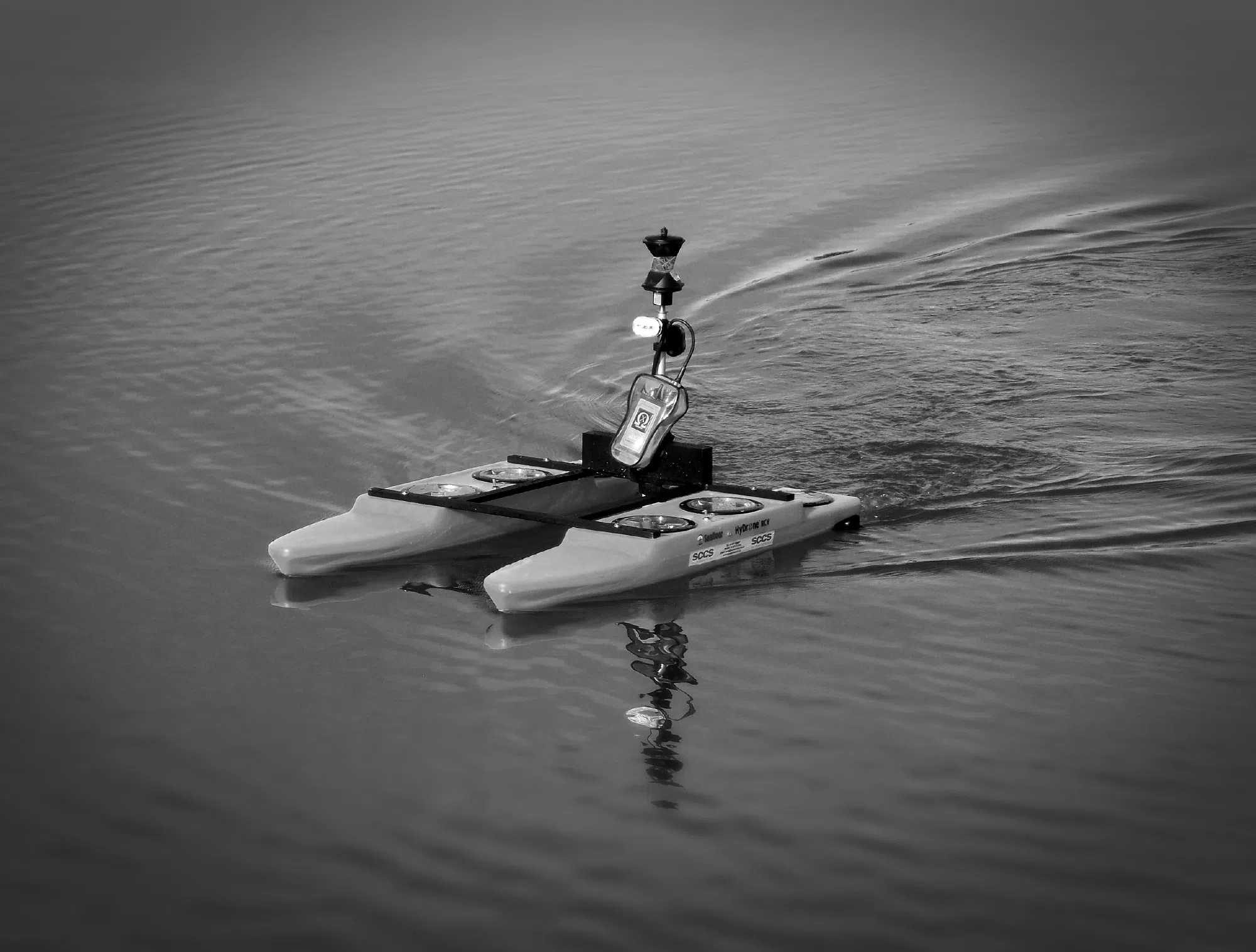
Remote Controlled Survey Vessels (USVs)
Some environments are not easy to access. Shallow water, steep banks, fast flows, or even contaminated areas can make traditional surveying difficult.
That is where our unmanned surface vessels come in.
These remote controlled platforms allow us to carry out surveys safely and efficiently, without putting people at risk. They are particularly useful in tight or hazardous locations where a standard boat simply would not work.
It also means quicker mobilisation and less disruption on site, which is always a bonus.
GNSS and Motion Referencing
Accuracy is everything in a bathymetric survey. If your positioning is off, your entire dataset becomes unreliable.
We use high precision GNSS systems combined with motion sensors to ensure every depth reading is correctly positioned and aligned to the national grid.
In simple terms, the data you receive will fit exactly with your existing drawings, models, and survey information. No awkward adjustments needed later.
Seamless Data Integration, Bank to Bank Modelling
This is where we really stand apart.
A common issue in the industry is the gap between underwater data and land data. Different surveys, different formats, and often a mismatch at the water’s edge.
That might not seem like a big deal at first, but when you are building a hydraulic model or designing infrastructure, those gaps can cause real headaches.
We bring everything together.
By combining bathymetric surveying with land topographical surveys, we create a continuous Digital Terrain Model that represents the entire site, above and below the waterline.
The result is a clean, consistent dataset that works exactly as it should.
If your project needs a wider scope, our comprehensive hydrographic survey solutions can support everything from basic depth mapping through to full environmental analysis.

Industry Standard Deliverables
Collecting data is only half the job. What really matters is how usable that data is when it lands with you.
We provide outputs in formats that slot straight into your workflow, whether you are working in CAD, GIS, or BIM environments.
Deliverables typically include:
- 2D bathymetric contour plans showing depth variations clearly
- 3D XYZ point cloud data for detailed analysis
- Digital Terrain Models for modelling and design
- Silt thickness and volume calculations
- CAD drawings ready for immediate use
- Revit compatible models for Scan to BIM projects
If you need something specific, just ask. We tailor outputs to suit your project, not the other way around.
Sectors We Serve
Our bathymetric survey services are used across a wide range of sectors, each with its own challenges.
- Construction, supporting bridge design, quay walls, and in water structures
- Environment, monitoring erosion, sediment movement, and habitats
- Utilities, mapping pipeline and cable routes, often alongside sub surface utility mapping
- Leisure, surveying marinas, lakes, and water features for maintenance or development
No two projects are the same, but the need for accurate data is consistent across all of them.
Why Choose Castle Surveys
There are plenty of companies offering bathymetric surveys. The difference is in how the work is delivered, and how useful the end result actually is.
At Castle Surveys, we focus on getting it right first time.
We work to RICS standards, so you can rely on the accuracy of the data. Our equipment is modern and well maintained, and we invest continuously to stay at the forefront of surveying technology.
More importantly, we take a practical, consultative approach. We will talk through your requirements, challenge assumptions where needed, and help you define a survey scope that makes sense technically and commercially.
Sometimes that means a high density multibeam survey. Other times, a simpler approach is more than enough. Either way, you will get honest advice.
Request a Quote for Your Bathymetric Survey
If you have a project coming up and need a clear understanding of what is happening below the waterline, we can help.
Get in touch with Castle Surveys to discuss your requirements. We will guide you through the options, recommend the right approach, and provide a clear, competitive quote.
Bathymetric Surveying FAQs
What is the difference between bathymetry and hydrography?
Bathymetry focuses specifically on measuring depths and mapping the underwater surface.
Hydrography is broader. It includes bathymetry, but also looks at things like tides, currents, and water conditions.
If you are unsure which you need, we are always happy to talk it through and point you in the right direction.
How deep can you survey?
Depth capability depends on the equipment and the site conditions, but for most inland and nearshore environments, we can cover the full range required. From very shallow ponds through to deeper reservoirs, it is all well within scope.
Can you survey in turbid or high flow water?
Yes, and this is where sonar based systems really prove their value. Unlike optical methods, they are not affected by poor visibility.
High flow conditions can add complexity, but with the right planning and equipment, accurate data can still be captured.
Explore Related Services
In addition to Bathymetric surveys, Castle Surveys offers a variety of complementary services to support your project from start to finish:
- Boundary Surveys: Clearly define your property lines in coastal and waterway developments. Learn more about our boundary surveys.
- Topographic Land Surveys: Detailed land elevation data for seamless integration with hydrographic mapping. Discover our topographic land surveys.
- Measured Building Surveys: Precise data on existing structures. Explore our measured building surveys.
- Utility Surveys: Identify and map buried utilities and underground infrastructure located near waterways or crossing survey areas, helping reduce project risk and avoid costly delays. Learn more about our utility survey services.