Mobile Surveying
Ever walked onto a site and instantly thought, “There’s got to be a better way to map all of this?” If that’s you, you’re in the right place. At Castle Surveys, we’re not just about collecting piles of data and hoping for the best. With mobile mapping surveys powered by Leica’s flagship TRK neo, we help developers, planners, and asset managers capture entire city blocks, highways, and industrial complexes quickly, safely, and, crucially, without losing sleep over missed details or patchy results.
Let’s be honest, the old ways of maneuvering tripods, dodging traffic, or spending weeks on site can be a bit like trying to map a motorway with a measuring tape. Mobile mapping surveys flip the script. In one day, you might cover what used to take a large team a week. That’s not just convenient, it’s a game changer, especially on congested, dangerous, or tricky sites. And honestly, clients always say the same thing after a big MMS job: “why didn’t we do this years ago?”
What Are Mobile Mapping Surveys?
Mobile mapping surveys are an advanced method of capturing high-accuracy geospatial data using sensors mounted to a vehicle. Instead of relying on static instruments and manual point-by-point measurements, mobile mapping enables surveyors to collect dense, 360-degree data while travelling at normal traffic speed.
At the heart of the process are high-resolution LiDAR scanners, GNSS receivers, and inertial measurement units (IMUs), often combined with panoramic cameras. Working together, these sensors record millions of points per second, building a precise digital model of the surrounding environment. The result is a detailed 3D point cloud that can be processed into CAD drawings, BIM models, and GIS datasets.
Unlike traditional topographic surveys, which require extended time on site and often involve lane closures or safety risks, mobile mapping technology drastically reduce fieldwork. This approach not only increases efficiency but also improves safety by minimising the need for surveyors to work on or near live roads and railways.
Why Choose Our Mobile Mapping Services Others?
We get it – you’ve probably been burned before by patchy data or costly resurveys.
With the Leica TRK neo, the heart of our mobile mapping system (MMS), you can look forward to these practical improvements:
- Reduce time on site: Fewer bodies in harm’s way, less disruption to traffic, business, or residents. It’s a win-win.
- Survey-grade accuracy: You’ll get millimetre-accurate positioning, thanks to GNSS, IMUs, and laser scanners working in harmony.
- Rich, dense 3D models: Everything from kerb lines to overhead cables is captured in crystal clarity, ready for your CAD, BIM, or GIS system.
- Repeatable, consistent results: Whether you’re mapping a road, railway, or city district, you’re assured of consistency when you return for updates or extensions.
- Data you can actually use: We’ll hand over files in formats you know – LAS, E57, DWG, DGN – so nothing gets lost in translation.
If you’ve ever had to revisit a site because something was missed, mobile mapping could be your new best mate. It’s transformed projects across the UK: reducing costs, improving safety, and giving decision-makers clear, actionable intelligence.
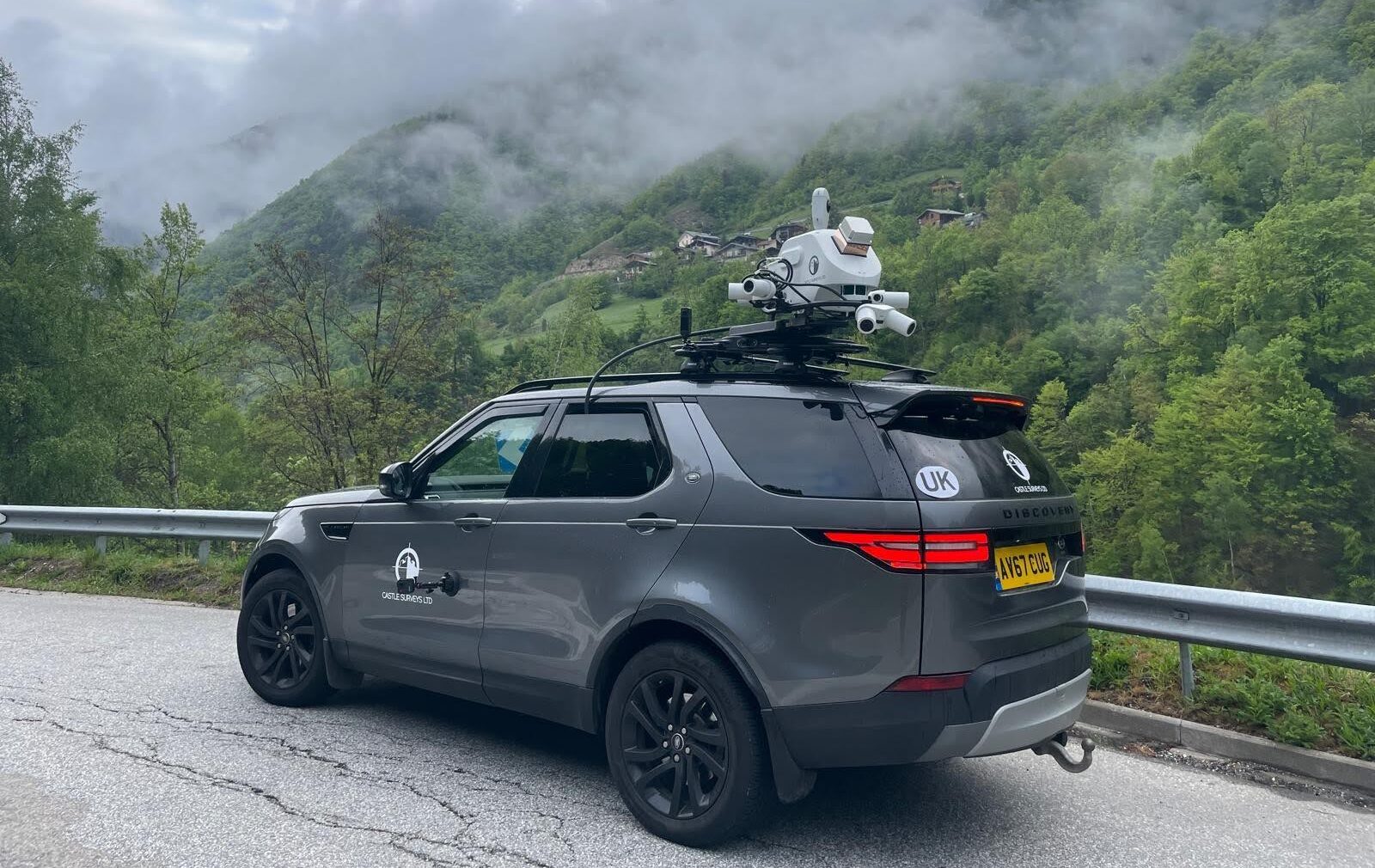
Technical Story: Meet the Leica TRK neo
Now, let’s pop the bonnet and see what makes the Leica TRK neo tick. This isn’t just any kit thrown onto a van. It’s a purpose-built mobile mapping system that’s earned its stripes on highways, railways, and city centres from the Isle of Wight to the M8.
Here’s what we love about it:
- Dual LiDAR scanners: Rotating at 240,000 pulses per second, these sensors capture 360° coverage, picking up everything from manhole covers to overhead signs, with zero distortion.
- GNSS and IMUs: The system knows its exact location at every moment, even through urban canyons or under dense foliage, with positioning that’s spot on.
- High-res imaging: Multiple cameras deliver colourised, georeferenced images, great for visual checks or presenting findings to stakeholders.
- Flexible mounting: Van, car, rail, or even backpack, we can fit the right platform for your site.
- Leica’s software suite: The data flows directly into your preferred design, mapping, or asset management system, with no awkward conversions or nasty surprises.
After years in the field, we’ve found the Leica TRK neo is more than just a scanner; it’s a Swiss Army knife for geospatial capture. You’re not just buying speed; you’re buying confidence.

The Castle Surveys Difference: Partner, Not Supplier
We’re not just a van with a scanner. Our job is to make sure your data is bulletproof before we even turn a wheel.
Here’s our approach:
- Start with a chat: Every survey begins with a conversation, not a contract. What are your objectives? What’s tricky about this site? What do you need to do with the data afterwards? These are the questions we ask, so you know exactly what you’ll get, and we know exactly what to deliver.
- Meticulous planning: We’ll scope out your site, assess access, and plan routes that maximise coverage while keeping disruption to a minimum. For busy roads or railways, we’ll coordinate with authorities and site managers, ensuring we’re there at the right time, in the right way.
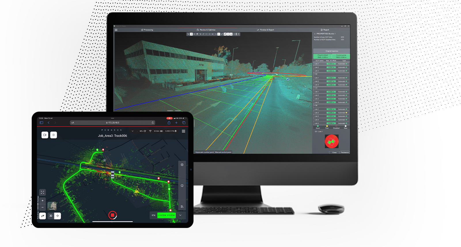
- Data capture with confidence: On the day, our experienced team will set up, calibrate, and get moving, all the while monitoring data quality in real time. If something needs adjusting, we’ll catch it immediately. No guesswork, no missed targets.
- Quality is king: Back at base, we’ll process the raw data through Leica’s rock-solid software, checking for gaps, misalignments, or oddities. We don’t just hand over a pile of files; we deliver validated, documented, ready-to-use data.
- Deliverables that work for you: 3D point clouds, digital terrain models, orthophotos, and asset registers. We’ll format the mobile mapping so it drops straight into your BIM, CAD, or GIS workflow. Need training for your team? We’re here for that, too.
Solving Common Mobile Mapping Headaches
Let’s not pretend mobile mapping is a silver bullet. Like any technology, it has its quirks. Here’s how we handle them:
- Accuracy and reliability: The Leica TRK neo is precise, but even the best kit needs a helping hand. We’ll deploy ground control points (GCPs) around your site to keep everything locked down. For really critical areas, we might augment with targeted terrestrial scans or drone surveys, just to make sure nothing slips through the net.
- Data density and coverage: Urban canyons, bridges, dense foliage can sometimes obscure the scanner’s view. We’ll plan overlapping runs and, where necessary, blend mobile mapping with static scans or UAV flights to fill the gaps.
- Legal and compliance: Flying cameras and scanners over public roads or near sensitive infrastructure needs careful thought. Our team is up to speed on the latest mobile mapping regulations, making sure your job stays compliant, on time, and on track.
- Chunky datasets: Mobile mapping can generate eye-watering amounts of data. We’ll work with you to deliver the right level of detail, in the right formats, so you’re not left drowning in files.
What Our Clients Say (and Why We’re Proud of It)
Results matter, and client stories matter even more. Here are a few ways we’ve made a difference with mobile mapping:
- Highway inventory: Mapped every sign, barrier, and kerb on 200km of motorway in a matter of days, giving a highways authority a living, up-to-date asset record.
- City centre regeneration: Built a digital twin for a city undergoing massive redevelopment, helping planners visualise new buildings, daylight impacts, and even local heritage concerns.
- Railway corridor: Surveyed a major train line, including tunnels and embankments, with results used for clearance checks and future electrification.
- Utilities mapping: Combined mobile mapping and GPR to map underground services along a busy high street, drastically reducing excavation risks and project delays.
Our clients tell us that our mapping services save time, make their teams safer, and deliver data that’s both trustworthy and easy to use. It’s not just about technology, it’s about partnership, clarity, and reliability.
Ready to Get Started?
If you’re curious about mobile mapping surveys, here’s how things usually move forward:
- Get in touch: Pick up the phone or drop us a line. We’ll chat about your site, the challenges you’re facing, and what you need from the data.
- Site review: We’ll look over your area remotely or visit in person, then give you a clear, tailored plan for capture.
- Proposal: You’ll receive a straightforward, no-surprises quote, clear on what you’re getting and when.
- Survey: Our team heads out, captures the site efficiently, and keeps you in the loop every step of the way.
- Delivery: We’ll process, quality check, and deliver your data, with support for integration, training, or ongoing needs.
It really is that simple. No jargon, no “we’ll get back to you,” just a smooth, expert service.

Frequently Asked Questions About Mobile Mapping
Wrapping Up: Mobile Mapping for the Real World
Mobile mapping surveys are changing the way we capture, manage, and use spatial data. With the Leica TRK neo and Castle Surveys behind you, you can expect rapid, trustworthy, and truly useful site intelligence, whether you’re planning a highway upgrade, a city makeover, or just keeping track of a sprawling estate.
So, if you’re ready for data that moves as fast as your project, pick up the phone and let’s talk. We’re here to help you get from “what’s possible” to “what’s next.”
For expert mobile mapping services, contact us at info@castlesurveys.co.uk or call our head office on 01530 569338 to discuss your project requirements and obtain a quote.