Scan Registration Services: Accurate Alignment for Building Surveys and Geospatial Mapping
At Castle Surveys, we provide expert scan registration services to align 3D laser scans precisely, ensuring accurate and comprehensive models for building surveys and geospatial mapping. Our advanced 3D scan alignment techniques and state-of-the-art laser scanning data processing ensure reliable results for projects of any size.
What Are Scan Registration Services?
Definition of Scan Registration
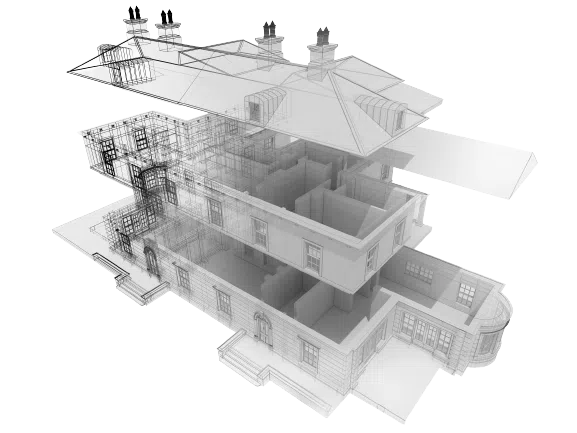
Scan registration is the process of aligning multiple 3D laser scans into one unified model, ensuring they fit together seamlessly to provide a precise representation of the surveyed area. Each individual scan captures a “point cloud”—a dense collection of data points representing physical features of the environment. Point cloud registration is the technique used to match and align these scans based on common reference points across each data set. The goal of scan registration is to create a single, accurate 3D model by combining data from different scan positions.
How It Works
The scan registration process begins with multiple 3D laser scans of the target area. Each scan captures a set of data points representing the environment from a specific perspective. However, each individual scan only partially represents the whole site, which is why it is crucial to align these scans accurately.
Scan registration services use specialised algorithms and software to identify common reference points between the point clouds. These reference points allow the software to match the scans and align them into a single model. The process is performed iteratively, refining the alignment until all the scans are seamlessly joined together. This ensures that the final 3D model is a highly accurate representation of the entire environment.
The Importance of Scan Registration in Building Surveys and Geospatial Mapping
Supporting Accurate Building Data Collection
In building surveys, accurate data collection is important for design, planning and construction. Scan registration ensures that data from multiple laser scans taken from various perspectives is accurately combined to create a comprehensive, unified 3D model. This model serves as the foundation for architectural and engineering decisions, allowing teams to measure distances, detect discrepancies, and visualise the space with high precision.
For example, in complex building surveys, where traditional methods might be inefficient or inaccurate, scan registration services provide a more efficient way to capture all the necessary details of a structure. Whether it’s measuring floor plans, assessing structural integrity or identifying areas for renovation, the accurate data provided by scan registration is invaluable for project success.
Enhancing Geospatial Mapping Accuracy
Scanning is equally important for geospatial mapping. Geospatial surveys often involve large areas, such as urban environments, infrastructure networks, or natural landscapes. Multiple scans are taken from different locations to ensure comprehensive coverage of the site. These scans are then registered together to create a seamless, detailed digital model of the entire area.
Accurate point cloud registration ensures that these scans are aligned correctly, preserving the spatial integrity of the data. Whether the project involves urban planning, environmental monitoring or infrastructure mapping, accurate scan registration allows for reliable geospatial models that can be used for analysis, planning, and decision-making.
How Castle Surveys Conducts Precise Scan Registration for 3D Laser Scanning
Techniques Used for 3D Scan Alignment
At Castle Surveys, we make use of advanced techniques for 3D scan alignment to ensure the highest level of accuracy in our surveys. Depending on the project’s complexity, we use both automatic and manual registration methods.
For simpler projects, automatic registration can be employed. The software automatically aligns the scans based on overlapping points or features between them. This process is quick and efficient, but in more complex environments—like large buildings or infrastructure networks—manual registration may be required for greater precision. Our team manually identifies and adjusts common reference points to ensure perfect alignment, providing a more refined and accurate model.
Both methods are supported by powerful software tools, such as ARO Scene, Leica Cyclone, and Cloudworx, which are industry leaders in point cloud registration and data processing. These tools help us align scans, clean the data, and generate reliable 3D models, ensuring that the data we deliver is accurate and ready for use in design and construction.
Tools and Technologies Employed for Laser Scanning Data Processing
Castle Surveys uses state-of-the-art tools and technologies for every step of the scan registration process. We rely on LiDAR scanners, which capture millions of data points from all angles, even in difficult-to-reach or hazardous areas. These high-resolution scanners provide an exceptionally detailed picture of the surveyed environment, capturing every detail required for accurate registration.
Once the data is collected, we register the scans using advanced point cloud processing software. This allows us to process, clean, and align the point clouds efficiently. These tools enable our team to produce highly accurate 3D models, which can then be used for further analysis, visualisation, or planning.
Key Benefits of Scan Registration for Surveying and Construction
It Improves the Accuracy of Site Surveys
One primary benefit of scan registration services is improving the accuracy of site surveys. Multiple scans, when registered correctly, create a more comprehensive and precise dataset than a single scan alone. This level of detail is essential for construction planning and design, where measurement accuracy is crucial. By aligning and merging multiple data sets, we eliminate discrepancies and ensure that the final model is highly accurate.
For example, in large-scale construction projects, precise measurements of the site are required to plan the layout of buildings, infrastructure, utilities, and more. Accurate scan registration helps avoid costly errors by providing a detailed and reliable representation of the site.
It Creates Reliable Digital Models for Project Visualisation
Another key benefit of scan registration is the creation of reliable 3D models for visualisation. These models allow architects, engineers, and other stakeholders to better understand the project in a virtual environment. Whether you’re working on a building survey, geospatial survey or construction project, having an accurate, integrated model provides a clear understanding of the space, making it easier to detect potential issues early and adjust plans accordingly.
These 3D models can also be used for virtual walkthroughs, helping clients and project teams visualise the project before construction even begins. This reduces the risk of design conflicts and ensures everyone involved is aligned on the project goals.
It Ensures Compliance with Industry Standards
We ensure that all scan registration work complies with industry standards for accuracy and data quality. Our team follows best practices for point cloud registration, ensuring that the data meets the necessary guidelines for construction, safety and regulatory compliance. This commitment to quality ensures that the models we deliver can be confidently used for further analysis, project planning and execution.
Contact Castle Surveys for Expert Scan Registration Services
If you need precise and reliable scan registration services for your building surveys or geospatial mapping, Castle Surveys is your trusted partner. Our team of experts is equipped with the latest tools and technologies to deliver accurate 3D models that help streamline project planning and decision-making.
Phone: 01530 569338
Email: info@castlesurveys.co.uk